
Tubmill Branch (Swan Creek tributary) facts for kids
Quick facts for kids Tubmill Branch |
|
|---|---|


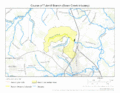
Location of Tubmill Branch mouth
|
|
| Other name(s) | Tributary to Mispillion River |
| Country | United States |
| State | Delaware |
| County | Kent |
| Physical characteristics | |
| Main source | Lednum Brannch divide Hall Estates, Delaware 44 ft (13 m) 38°56′36″N 075°27′49″W / 38.94333°N 75.46361°W |
| River mouth | Swan Creek at Tubmill Pond about 0.5 miles south of Lynch Heights, Delaware 10 ft (3.0 m) 38°56′35″N 075°25′50″W / 38.94306°N 75.43056°W |
| Length | 2.16 mi (3.48 km) |
| Basin features | |
| Progression | northeast then southeast |
| River system | Mispillion River |
| Basin size | 3.32 square miles (8.6 km2) |
| Tributaries |
|
| Bridges | DE 15, Bowman Road, Church Hill Road |
Tubmill Branch is a small stream, about 2.16 miles (3.48 km) long. It flows into Swan Creek, which is part of the Mispillion River system in Delaware. This stream is located in Kent County, Delaware. Did you know there's another stream with the same name in the United States? The other Tubmill Branch is in Caroline County, Maryland.
Where Tubmill Branch Starts and Flows
Tubmill Branch begins in an area called the Lednum Branch divide. This is about half a mile south of a place called Lynch Heights in Delaware.
From its start, Tubmill Branch first flows towards the northeast. Then, it changes direction and flows towards the southeast. Finally, it meets Swan Creek near Hall Estates, Delaware.
The Land Around Tubmill Branch
The area that Tubmill Branch drains is called its watershed. This watershed covers about 3.32 square miles (8.6 square kilometers). This means all the rain that falls in this area eventually flows into Tubmill Branch.
The region around the stream gets about 45.7 inches (116 cm) of rain each year. About 8.3% of the land in this watershed is covered by forests. This shows that the area has a mix of open spaces and trees.
Images for kids
-
The path Tubmill Branch takes
-
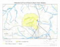
The area of land that drains into Tubmill Branch
.gif)
.gif)
