
Tununak, Alaska facts for kids
Quick facts for kids
Tununak
Tununeq
|
|
|---|---|
.jpg)
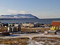
Aerial view of Tununak
|
|

Tununak, Alaska
Location in Alaska
|
|
| Country | United States |
| State | Alaska |
| Census Area | Bethel |
| Area | |
| • Total | 60.95 sq mi (157.85 km2) |
| • Land | 60.71 sq mi (157.23 km2) |
| • Water | 0.24 sq mi (0.62 km2) |
| Population
(2020)
|
|
| • Total | 411 |
| • Density | 6.77/sq mi (2.61/km2) |
| Time zone | UTC-9 (Alaska (AKST)) |
| • Summer (DST) | UTC-8 (AKDT) |
| ZIP code |
99681
|
| Area code(s) | 907 |
| FIPS code | 02-79230 |
Tununak (pronounced Too-new-nak), also known as Tununeq in the local Yup'ik language, is a small community in Alaska, United States. It is a special type of place called a census-designated place (CDP). In 2020, about 411 people lived there.
Contents
Where is Tununak Located?
Tununak is found at 60°34′50″N 165°15′34″W / 60.58056°N 165.25944°W on the northwest side of Nelson Island. This island is in the Bering Sea, which is part of the Pacific Ocean.
The village is about 5 miles (8 kilometers) away from a nearby village called Toksook Bay. There is a path that connects these two villages and can be used all year round.
The total area of Tununak is about 60.7 square miles (157.2 square kilometers). Most of this area is land, with only a small part being water.
How Many People Live Here?
| Historical population | |||
|---|---|---|---|
| Census | Pop. | %± | |
| 1880 | 8 | — | |
| 1890 | 48 | 500.0% | |
| 1940 | 65 | — | |
| 1950 | 112 | 72.3% | |
| 1960 | 183 | 63.4% | |
| 1970 | 274 | 49.7% | |
| 1980 | 298 | 8.8% | |
| 1990 | 316 | 6.0% | |
| 2000 | 325 | 2.8% | |
| 2010 | 327 | 0.6% | |
| 2020 | 411 | 25.7% | |
| U.S. Decennial Census | |||
The first time Tununak appeared in a U.S. Census was in 1880. Back then, it was called "Tanunak" and had only 8 residents, all of whom were Inuit people.
Over the years, the population has grown. By 2020, there were 411 people living in Tununak. Most of the people living here are Yupik, who are Native Alaskans.
In 2000, about 42.5% of the people were under 18 years old. The average age was 23 years, which means it's a community with many young people.
Community Life
In 2003, Tununak had about seventy houses. There were also two shops where people could buy things, and a place to rent movies.
Learning in Tununak
The Lower Kuskokwim School District runs the Paul T. Albert Memorial School in Tununak. This school teaches students from kindergarten all the way through 12th grade.
It's a special school because it teaches in both English and Yugtun, which is the Yup'ik language. In 2018, about 108 students attended the school, and all of them were Alaska Natives.
Many students at the school speak Yup'ik at home and are very good at the language. This helps keep the Yup'ik language alive.
Getting Around Tununak
Tununak has its own small airport, called Tununak Airport. This is an important way for people to travel to and from the community, especially since it's on an island.
There is also one main road within the community itself.
-
Tununak
-
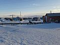
Tununak in the winter
-
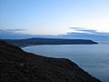
View towards Tununak from the north
-
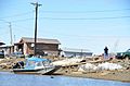
Houses in Tununak
.jpg)
.jpg)
.jpg)
.jpg)
See also
 In Spanish: Tununak (Alaska) para niños
