Tusayan, Arizona facts for kids
Quick facts for kids
Tusayan, Arizona
|
||
|---|---|---|

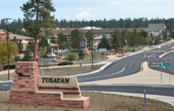
The Tusayan welcome sign with town behind
|
||
|
||

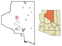
Location of Tusayan in Coconino County, Arizona.
|
||
| Country | United States | |
| State | Arizona | |
| County | Coconino | |
| Incorporated | 2010 | |
| Area | ||
| • Total | 16.82 sq mi (43.58 km2) | |
| • Land | 16.82 sq mi (43.58 km2) | |
| • Water | 0.00 sq mi (0.00 km2) | |
| Elevation | 6,746 ft (2,056 m) | |
| Population
(2020)
|
||
| • Total | 603 | |
| • Density | 35.84/sq mi (13.84/km2) | |
| Time zone | UTC−7 (MST) | |
| ZIP code |
86023
|
|
| Area code | 928 | |
| FIPS code | 04-77490 | |
| GNIS feature ID | 2663676 | |
| Website | Town of Tusayan | |
Tusayan is a small town in Coconino County, Arizona, United States. It became an official town in 2010. It is a popular place for visitors because it is very close to the south entrance of the Grand Canyon National Park. In 2010, about 558 people lived there. By 2020, the population grew to 603 people.
Contents
Where is Tusayan Located?
Tusayan is a very small town in terms of its land area. It covers only about 144 acres, which is roughly 0.225 square miles. This makes it one of the smallest towns in Arizona by size.
What is the Climate Like?
Tusayan has a unique climate. It can be described as having warm, dry summers and cool, wet winters.
Summer Weather in Tusayan
Summer days are often hot, but the nights are cool and refreshing. For example, in June, the average high temperature is around 82 degrees Fahrenheit. But the average low temperature drops to about 40 degrees Fahrenheit. This big difference between day and night temperatures is common here.
Winter Weather in Tusayan
Winters in Tusayan are generally cold. High temperatures are usually in the 40s, and low temperatures can drop into the teens. It can also get very cold, with record lows reaching -30 degrees Fahrenheit in December.
Rain and Snowfall
Tusayan gets some rain, especially in July and August. These months have the most rainfall. Snow is also common in winter.
| Climate data for Grand Canyon National Park Airport, AZ | |||||||||||||
|---|---|---|---|---|---|---|---|---|---|---|---|---|---|
| Month | Jan | Feb | Mar | Apr | May | Jun | Jul | Aug | Sep | Oct | Nov | Dec | Year |
| Record high °F (°C) | 70 (21) |
66 (19) |
75 (24) |
81 (27) |
91 (33) |
97 (36) |
99 (37) |
94 (34) |
88 (31) |
85 (29) |
74 (23) |
66 (19) |
99 (37) |
| Mean daily maximum °F (°C) | 44.6 (7.0) |
45.9 (7.7) |
54.2 (12.3) |
60.7 (15.9) |
72.1 (22.3) |
82.6 (28.1) |
85.8 (29.9) |
82.7 (28.2) |
76.4 (24.7) |
64.7 (18.2) |
54.0 (12.2) |
43.8 (6.6) |
64.0 (17.8) |
| Mean daily minimum °F (°C) | 13.7 (−10.2) |
16.0 (−8.9) |
19.9 (−6.7) |
24.3 (−4.3) |
30.4 (−0.9) |
36.8 (2.7) |
48.8 (9.3) |
48.1 (8.9) |
39.8 (4.3) |
28.3 (−2.1) |
19.9 (−6.7) |
12.8 (−10.7) |
28.2 (−2.1) |
| Record low °F (°C) | −29 (−34) |
−17 (−27) |
−8 (−22) |
3 (−16) |
11 (−12) |
21 (−6) |
28 (−2) |
29 (−2) |
21 (−6) |
6 (−14) |
−8 (−22) |
−30 (−34) |
−30 (−34) |
| Average precipitation inches (mm) | 0.97 (25) |
0.98 (25) |
0.96 (24) |
0.88 (22) |
0.37 (9.4) |
0.28 (7.1) |
2.23 (57) |
2.23 (57) |
1.48 (38) |
1.45 (37) |
0.71 (18) |
0.83 (21) |
13.37 (340.5) |
| Average precipitation days (≥ 0.01 in) | 6 | 7 | 6 | 6 | 3 | 2 | 12 | 12 | 7 | 5 | 4 | 6 | 76 |
| Source: https://w2.weather.gov/climate/xmacis.php?wfo=fgz | |||||||||||||
Who Lives in Tusayan?
| Historical population | |||
|---|---|---|---|
| Census | Pop. | %± | |
| 2000 | 562 | — | |
| 2010 | 558 | −0.7% | |
| 2020 | 603 | 8.1% | |
| U.S. Decennial Census | |||
In 2000, there were 562 people living in Tusayan. About 222 homes were counted. The population density was about 19.7 people per square mile.
Diversity in Tusayan
The people living in Tusayan come from different backgrounds. In 2000, about 69% of the residents were White. Around 16% were Native Americans. About 1% were Black or African American. Also, about 12% were from other races. Around 30% of the population identified as Hispanic or Latino.
Age and Families
The average age of people in Tusayan in 2000 was 31 years old. About 25% of the population was under 18. Many households (about 54%) were not families. This means they were individuals living alone or groups of unrelated people.
What is Tusayan's Economy Like?
Tusayan is very important for tourism. It is only about one mile from the south entrance to the Grand Canyon National Park. Most businesses in Tusayan serve the many tourists who visit the park.
Hotels and Tourism
The town has many hotels, with about 1,100 rooms available. This is even more hotel rooms than what is available inside the Grand Canyon National Park itself. Some local people hope to make Tusayan a tourist spot on its own, not just a place to stay before visiting the Grand Canyon.
How Do People Get Around?
Tusayan has its own airport, the Grand Canyon National Park Airport. This makes it easy for visitors to fly in.
Roads and Highways
Two main roads, Arizona State Route 64 and U.S. Route 180, lead to Tusayan. They combine into a four-lane highway as they pass through the town. Outside of town, they become two-lane roads.
How Tusayan Became a Town
The idea of Tusayan becoming an official town started in the early 1990s. It took many years and votes for it to happen.
Early Attempts to Incorporate
In 2003, a new law was passed. It allowed communities with 500 or more people near a national park to become towns. A group of people from the Tusayan-Grand Canyon Chamber of Commerce studied this for four years. In 2008, people voted on whether Tusayan should become a town, but the idea was defeated.
Becoming an Official Town
Another vote was held on March 9, 2010. This time, the measure passed with more votes in favor. Tusayan officially became the 91st incorporated town in Arizona. An interim town council then held the town's first meeting on April 7, 2010.
Education in Tusayan
Most students in Tusayan attend schools within the Grand Canyon Unified School District. A small part of the town is in the Williams Unified School District. The high school for the Grand Canyon district is Grand Canyon High School.
See also
 In Spanish: Tusayan para niños
 | Madam C. J. Walker |
 | Janet Emerson Bashen |
 | Annie Turnbo Malone |
 | Maggie L. Walker |


