Tébessa Province facts for kids
Quick facts for kids
Tébessa Province
ولاية تبسة
|
|
|---|---|

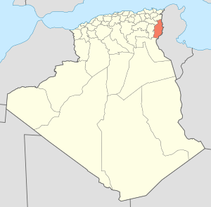
Map of Algeria highlighting Tébessa
|
|
| Country | |
| Capital | Tébessa |
| Area | |
| • Total | 14,227 km2 (5,493 sq mi) |
| Population
(2008)
|
|
| • Total | 657,227 |
| • Density | 46.1958/km2 (119.646/sq mi) |
| Time zone | UTC+01 (CET) |
| Area Code | +213 (0) 37 |
| ISO 3166 code | DZ-12 |
| Districts | 12 |
| Municipalities | 28 |
Tébessa Province is a region in Algeria, a country in North Africa. It is like a large state or county. The main city and capital of this province is also called Tébessa.
This province is located in the eastern part of Algeria. It is very close to the border with Tunisia, only about 20 kilometers (12 miles) away. Another important city in the province is El Ouenza.
Contents
How is Tébessa Province Organized?
Tébessa Province is divided into smaller areas to help manage it. These areas are called districts and municipalities.
What are the Districts?
The province has 12 main districts. Each district includes several smaller towns or areas.
- Bir El Ater
- Bir Mokadem
- Cheria
- El Aouïnet
- El Kouif
- El Ma Labiodh
- El Ogla
- Morsott
- Negrine
- Ouenza
- Oum Ali
- Tébessa
What are Municipalities?
Within these 12 districts, there are 28 smaller areas called communes or municipalities. These are like local towns or villages that have their own local governments.
See also
 In Spanish: Provincia de Tébessa para niños
 | Kyle Baker |
 | Joseph Yoakum |
 | Laura Wheeler Waring |
 | Henry Ossawa Tanner |

