Uei-tepui facts for kids
Quick facts for kids Uei-tepui |
|
|---|---|

Uei-tepui in 2013
|
|
| Highest point | |
| Elevation | 2,150 m (7,050 ft) |
| Geography | |
| Location | Roraima, Brazil / Bolívar, Venezuela |
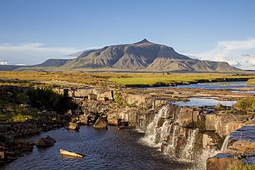
Uei-tepui, also called Wei-tepui, Cerro El Sol, or Serra do Sol, is a special type of flat-topped mountain called a tepui. It sits right on the border between Brazil and Venezuela. Many people think it's the most southern mountain in a group known as the Eastern Tepuis.
Uei-tepui stands about 2,150 meters (7,050 feet) tall. Its flat top covers an area of about 2.5 square kilometers (1 square mile). The sides of the mountain, or its slopes, stretch out over an estimated 20 square kilometers (8 square miles). Even though the very top of Uei-tepui is completely in Venezuela, a big part of its main ridge forms the natural boundary between Venezuela and Brazil.
Contents
What is a Tepui?
A tepui is like a giant, flat-topped mountain or mesa. These unique landforms are mostly found in the Guiana Highlands of South America, especially in Venezuela and Brazil. The word "tepui" means "house of the gods" in the native Pemon language. This name shows how important and mysterious these mountains are to the local people.
How are Tepuis Formed?
Tepuis are made of very old sandstone rock. They formed over millions of years as the land around them eroded, or wore away, leaving these tough, flat-topped mountains standing tall. Because they are so isolated and have such steep sides, many plants and animals found on tepuis exist nowhere else on Earth.
Where is Uei-tepui Located?
Uei-tepui is located in a remote part of South America. It is part of the Guiana Highlands, a region known for its incredible biodiversity and unique landscapes.
Border Between Countries
This tepui is special because it marks a part of the border between two countries:
- Brazil: Specifically, it's near the state of Roraima.
- Venezuela: It's located in the state of Bolívar.
The fact that it's on the border makes it an important geographical landmark.
See also
 In Spanish: Uei (tepuy) para niños
- Distribution of Heliamphora
 | Valerie Thomas |
 | Frederick McKinley Jones |
 | George Edward Alcorn Jr. |
 | Thomas Mensah |


