Ujelang Atoll facts for kids

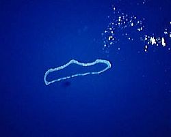
NASA picture of Ujelang Atoll
|
|
| Geography | |
|---|---|
| Location | North Pacific |
| Coordinates | 9°49′20″N 160°54′0″E / 9.82222°N 160.90000°E |
| Archipelago | Ralik |
| Total islands | 30 |
| Area | 1.86 km2 (0.72 sq mi) |
| Highest elevation | 3 m (10 ft) |
| Administration | |
| Demographics | |
| Population | 0 |
| Ethnic groups | Marshallese (formerly) |
Ujelang Atoll is a group of 30 small islands in the Pacific Ocean. It's part of the Marshall Islands, a country made up of many atolls. An atoll is a ring-shaped coral reef, island, or series of islets. It surrounds a body of water called a lagoon.
Ujelang Atoll has a total land area of about 1.86 square kilometers (0.72 square miles). Its lagoon is much bigger, covering about 185.94 square kilometers (71.79 square miles). It's the most western island in the Marshall Islands. It's about 217 kilometers (135 miles) southeast of Enewetak and about 600 kilometers (373 miles) west of the main group of islands in the Ralik Chain. Today, no one lives permanently on Ujelang Atoll.
Contents
History of Ujelang Atoll
Early European Visitors
The first European to see Ujelang Atoll was Álvaro de Saavedra in 1529. He was on a journey trying to sail back to New Spain (which is now Mexico). Other Spanish explorers also recorded seeing Ujelang in the 1540s and 1560s.
German Ownership and Japanese Control
In 1811, a British merchant ship named Providence found the atoll again. They named Ujelang Island "Providence Island."
In 1884, the Empire of Germany claimed Ujelang Atoll and the rest of the Marshall Islands. German trading companies owned the atoll from 1880. They grew coconuts to make copra (dried coconut meat) on the largest island, also called Ujelang.
After World War I, Japan took control of the island. It became part of the South Seas Mandate, which was a group of islands Japan was allowed to govern. By 1935, only about 40 people lived there.
World War II and US Control
During World War II, the United States Army used Ujelang as a stopping point. Soldiers landed there in April 1944 before moving to other islands.
After World War II, the United States took control of Ujelang. It was part of the Trust Territory of the Pacific Islands. This lasted until the Marshall Islands became independent in 1986.
Relocation and Return to Enewetak
In 1947, Ujelang became a new home for people from Enewetak Atoll. They had to move because of atomic tests happening on Enewetak from 1948 to 1958.
The population on Ujelang grew from 145 people in 1947 to 342 people in 1973. Life was hard at times, with not enough fish or vegetables. The people really wanted to go back to Enewetak.
In 1979, a big meeting was held on Ujelang to talk about returning home. The US government sent people from the Department of Energy and the Department of Interior. The TV show 60 Minutes even filmed the meeting. This helped share the islanders' story with many people.
Clean-up and Final Departure
The US government worked to clean up Enewetak. They planted many new coconut trees. They also buried radioactive material under a large concrete dome.
In 1980, all the people from Ujelang moved back to Enewetak. However, Enewetak couldn't support so many people. About 100 people soon returned to Ujelang, but their stay was short. By 1989, Ujelang became completely uninhabited.
Today, Ujelang Atoll is owned by the Enewetak Council. It is visited very rarely.
See also
 In Spanish: Ujelang para niños
- Ujlān volcanic complex
- Desert island
- List of islands
 | DeHart Hubbard |
 | Wilma Rudolph |
 | Jesse Owens |
 | Jackie Joyner-Kersee |
 | Major Taylor |


