Ulster Township, Pennsylvania facts for kids
Quick facts for kids
Ulster Township,
Pennsylvania |
|
|---|---|
|
Township
|
|

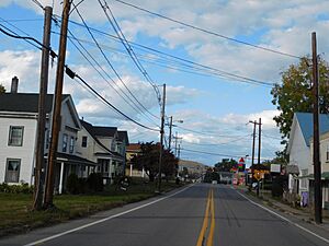
Northbound US 220 (Main Street) in the village of Ulster, within the township
|
|

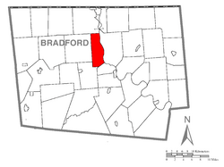
Map of Bradford County with Ulster Township highlighted
|
|

Map of Bradford County, Pennsylvania
|
|
| Country | United States |
| State | Pennsylvania |
| County | Bradford |
| Settled | 1785 |
| Incorporated | 1797 |
| Area | |
| • Total | 19.53 sq mi (50.58 km2) |
| • Land | 18.74 sq mi (48.53 km2) |
| • Water | 0.79 sq mi (2.04 km2) |
| Population
(2010)
|
|
| • Total | 1,337 |
| • Estimate
(2016)
|
1,302 |
| • Density | 69.48/sq mi (26.83/km2) |
| Area code(s) | 570 |
| FIPS code | 42-015-78232 |
Ulster Township is a small community located in Bradford County, Pennsylvania. It's part of the wider Northeastern Pennsylvania region. In 2010, about 1,337 people lived here. The township got its name from Ulster, a province in Ireland.
Contents
Geography and Location
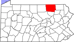
Ulster Township is found in the north-central part of Bradford County. It sits on the west side of the Susquehanna River.
Neighboring Areas
Ulster Township shares its borders with several other communities:
- To the north: Athens Township
- To the east: Sheshequin Township (across the Susquehanna River)
- To the southeast: North Towanda Township
- To the south and west: Burlington Township
- To the west: Smithfield Township
Roads and Waterways
U.S. Route 220 is a main road that goes through the township. It runs along the west side of the Susquehanna River. Along this road, you'll find the small communities of Ulster (which is the biggest settlement) and Milan. A bridge called Bridge Street connects the village of Ulster to Sheshequin Township across the river.
Land and Water Area
The United States Census Bureau says that Ulster Township covers about 50.6 square kilometers (19.5 square miles). Most of this area, about 48.5 square kilometers (18.7 square miles), is land. The rest, about 2.0 square kilometers (0.79 square miles), is water, making up about 4.04% of the total area.
Population and People
| Historical population | |||
|---|---|---|---|
| Census | Pop. | %± | |
| 2010 | 1,337 | — | |
| 2016 (est.) | 1,302 | −2.6% | |
| U.S. Decennial Census | |||
In 2000, there were 1,340 people living in Ulster Township. These people lived in 512 households, and 379 of these were families. The population density was about 70.6 people per square mile (27.3 people per square kilometer).
Community Makeup
Most of the people in the township (97.54%) were White. There were also small numbers of African American (0.45%), Native American (1.04%), and Asian (0.15%) residents. About 0.67% of the population identified as Hispanic or Latino.
Households and Families
Out of the 512 households, about 35.4% had children under 18 living with them. Most households (62.7%) were married couples living together. About 21.5% of all households were made up of people living alone.
Age Distribution
The population in the township was spread out by age:
- 27.3% were under 18 years old.
- 6.0% were between 18 and 24 years old.
- 29.3% were between 25 and 44 years old.
- 23.9% were between 45 and 64 years old.
- 13.6% were 65 years old or older.
The average age in the township was 37 years old.
Income Levels
In 2000, the average income for a household in the township was $38,281. For families, the average income was $41,522. The per capita income (income per person) for the township was $16,411. About 8.1% of the total population lived below the poverty line.
Notable People
Some interesting people have connections to Ulster Township:
- Ethan B. Minier: He was born in the township and later became a legislator, farmer, and lawyer in Wisconsin.
- Esther Montour: She was a leader of a group of Lenape people during the American Revolution.
See also
 In Spanish: Municipio de Ulster (Pensilvania) para niños

