Unalaska Bay facts for kids
Quick facts for kids Unalaska Bay |
|
|---|---|

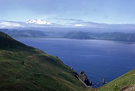
Broad Bay and the Makushin Volcano partly hidden by low clouds and the Makushin valley.
|
|
| Coordinates | 53°56′55″N 166°29′54″W / 53.94861°N 166.49833°W |
| Type | Bay |
| Ocean/sea sources | Pacific Ocean |
| Basin countries | United States |
| Max. length | n/a |
| Max. width | n/a |
| Surface area | n/a |
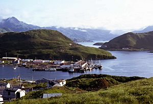
| Settlements | Dutch Harbor Unalaska |
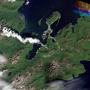
Unalaska Bay is a large body of water located on Unalaska Island in Alaska, United States. It sits near the eastern side of the Makushin Volcano. This bay is actually made up of seven smaller bays and opens into the Bering Sea.
Contents
Exploring Unalaska Bay
Unalaska Bay is a big inlet at the northern end of Unalaska Island. It stretches between two points called Cape Kalekhta and Cape Cheerful. Long ago, it was a very important bay for trade in western Alaska. The land around the bay is mostly mountainous, with steep cliffs facing the sea.
Islands and Harbors
Amaknak Island is located at the southern part of Unalaska Bay. West of this island, the water is deep, but there aren't many good places for boats to stop. East of Amaknak Island, you'll find important harbors like Dutch Harbor, Iliuliuk Bay, and Iliuliuk Harbor. The path to Dutch Harbor and Iliuliuk Bay is usually clear, but Iliuliuk Harbor has some rocky areas at its entrance.
Key Landmarks
Cape Cheerful
Cape Cheerful is a bold, high piece of land at the western entrance of Unalaska Bay. Its top is rounded, and it has deep, grassy valleys. The water near the shore is deep and safe. There's a 125-foot waterfall south of Cape Cheerful. This waterfall is easy to spot, especially when fog hides the higher parts of the land.
Ulakhta Head
Ulakhta Head is a 900-foot tall landmark on the north end of Amaknak Island. On a clear day, it's one of the best ways to find Unalaska Bay. It looks like a pyramid with its top cut off, making it flat on top. No other mountain nearby looks quite like it. Even though it's not the tallest, it stands out against the background and can be seen from far away.
Princess Head
About 2 miles from Cape Kalekhta, you'll find Princess Head. This is a large, square-shaped rock that sticks out from the shore. It's easy to see, even in foggy weather, as you travel along the eastern side of the bay.
Smaller Bays to Know About
Constantine Bay
Constantine Bay is about 4 miles from Cape Kalekhta. This bay has many rocky areas, some of which are hidden by seaweed. It's not an important bay for boats and should be avoided.
Summer Bay
Summer Bay is a large, shallow area about 3 miles from Constantine Bay. It's opposite Ulakhta Head. This bay is shallow, and its shores have many rocks and ledges, often covered in seaweed. At its southern end, there's a rock called Pinnacle Rock, which is about 60 feet tall. While this bay is a great place to fish for salmon, boats should stay away from it.
Iliuliuk Bay
Iliuliuk Bay stretches from Pinnacle Rock and Ulakhta Head to the village of Iliuliuk. There's a slightly raised area across the bay with water depths of about 10 fathoms (60 feet). South of this area, the water gets deeper, up to 16 to 19 fathoms (96 to 114 feet). Boats can anchor anywhere in this bay. The best spot is usually at the end of the bay, where the water is 14 to 16 fathoms deep and the bottom is muddy. Even when winds come from the north, the waves don't seem to reach this spot strongly.
Other Bays
Southwest of Amaknak Island is a long, narrow inlet called Captains Bay. There's a small passage from Captains Bay to Iliuliuk Harbor. On the western side of Unalaska Bay, you'll find Nateekin Bay, Broad Bay, and Eider Point Anchorage.
Finding Your Way to Unalaska Bay
If you're coming to Unalaska Bay from the Bering Sea, it's a good idea to aim for Cape Cheerful. If the weather is foggy, it's safer to approach from the west of Cape Cheerful and then go around it, rather than coming from the east where there are more tricky passages.
Makushin Volcano, which is 5,474 feet tall, can usually be seen on clear days and is a very clear landmark. There's also an old volcano crater, 2,314 feet high, behind Cape Cheerful and west of Eider Point. This crater is a good point to aim for until you get close enough to see other features.
When you're near the island and fog is low, Wislow Island can be a helpful landmark. It's a small, round island that stands out from the main island. Sometimes, Makushin Cape can be seen from the west in similar foggy conditions. The land gently slopes down to this cape from Makushin Volcano, ending in a small peak. From the east, the waterfall south of Cape Cheerful is also useful.
If you're new to the area and not sure about the landmarks, try to find Ulakhta Head. When you look into the bay, its flat top that suddenly drops to sloping sides looks different from anything else nearby. It stands out well against the mountains behind it.
Staying Safe: Dangers in the Bay
Boaters should always avoid areas with a lot of seaweed, as this usually means there are rocks hidden below.
- Constantine Bay: A group of rocks, mostly just below the water's surface and often marked by waves, extends almost 200 yards west of the southern end of Constantine Bay.
- Pinnacle Rock: This rock is surrounded by reefs, both above and below water, for about 300 yards.
- East Shore: Between Pinnacle Rock and the entrance to Dutch Harbor, the eastern shore has many rocks. Boats should not get closer than 4 miles to this area.
- The Spit: This long, narrow sandbar has a shallow area on its east side, marked by seaweed, that runs its whole length. In the middle, this shallow area extends 4 miles from the shore. The very end of the spit, called Spithead, is safe to approach as close as 150 yards. There's a beacon, about 15 feet tall, near its southern shore.
- Rocky Point: This point has a reef marked by seaweed that stretches about 350 yards toward Spithead. East of the point, shallow water extends about 200 yards, but with little seaweed. The northern end of this reef is marked by a white buoy. South from Rocky Point, boats should not get closer than 300 yards to the shore of Amaknak Island.
- Iliuliuk Reef: This is a ledge of rocks, with some parts always visible, stretching about 250 yards from east to west. From the eastern dry rock, a seaweed-marked ledge extends south-southeast for about 150 yards. The southern end of this ledge is sometimes marked by a buoy.
- Tuscarora Rock: This rock, marked by seaweed, is about 50 yards south-southeast from the southern end of Iliuliuk Reef. It's small and usually marked by an iron barrel buoy. These buoys used to be maintained by the Alaska Commercial Company.
 | Selma Burke |
 | Pauline Powell Burns |
 | Frederick J. Brown |
 | Robert Blackburn |


