Makushin Volcano facts for kids
Quick facts for kids Makushin Volcano |
|
|---|---|
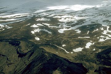
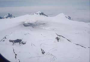
Aerial view of the Point Kadin vents, a series of post- glacial explosion pits and small cinder cones that occur along a fracture zone northwest of the summit of Makushin Volcano
|
|
| Highest point | |
| Elevation | 2,036 m (6,680 ft) |
| Prominence | 2,036 m (6,680 ft) |
| Listing |
|
| Geography | |
| Parent range | Aleutian Range |
| Topo map | USGS Unalaska C-3 |
| Geology | |
| Age of rock | Early Pliocene |
| Mountain type | Stratovolcano with caldera and parasitic cone |
| Volcanic arc/belt | Aleutian Arc |
| Last eruption | January 1995 |
| Climbing | |
| First ascent | George Davidson in 1867 |
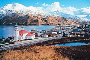
The Makushin Volcano, also called Mount Makushin, is a huge, ice-covered volcano. You can find it on Unalaska Island in the Aleutian Islands of Alaska, USA. It's a type of volcano called a stratovolcano, which means it's tall and cone-shaped.
At 2,036 meters (6,680 ft) high, its top is the highest spot on Unalaska Island. Makushin is one of Alaska's busiest volcanoes, having erupted many times. Its last eruption was in 1995.
Contents
What's in a Name? Makushin's History
In 1792, a person named Sarichev called the volcano "Ognedyshushchaya Gora". This Russian name means "fire-breathing mountain," which is another way to say volcano. Later, in 1825, it became known as Makuschkin Volcano.
This name might come from the Russian word makushka. That word means "the top of the head." The native people, called the Aleuts, had their own name for it: Aigagin. This name comes from their word Aigak.
There was also a native village named Makushin on the northern shore of Makushin Bay. The leader of the Russian American Company lived there. This village had six huts where 35 native people lived.
The Alaska Volcano Observatory has found many other names for Makushin Volcano. Some of these include "Ajagin Wesselow," "Cheerful Mtn.," and "Makishinskaia sopka." There are also four special spots nearby: Red Cinder Dome, Pakushin cone, the Sugarloaf, and the Point Kadin vents.
Makushin's Past: How it Formed and When it Erupted
How Makushin Volcano Began
Scientists believe Makushin Volcano started forming a very long time ago. This was during the Early Pliocene age. However, the large bowl-shaped hollow at the top, called a caldera, is much younger. It formed about 8,000 years ago.
Smaller features like the "Sugarloaf cone" and the "Point Kadin vents" are even more recent. They formed during the Holocene age. This shows that the volcano has been active for a very long time.
According to the Alaska Volcano Observatory, the volcano's history began with lava flows. These flows made Unalaska Island much bigger along its northwest coast. The older lava flows show signs of being covered by glaciers. This means they are at least from the late Pleistocene ice age.
Later, the top of Makushin Volcano collapsed, creating its summit caldera. This big eruption also sent out ash and rock flows. These flows filled valleys on the north and south sides of the volcano.
Makushin's Eruption History
Makushin is one of the most active volcanoes in the Aleutian Islands. It has erupted at least two dozen times over thousands of years. The last eruption happened in 1995. Since 1786, there have been 17 recorded eruptions or explosions. Most of these were small to medium in size.
Some recorded eruption years include 1768–69, 1802, 1865, 1907, 1938, and 1980. Makushin's last big eruption was on January 30, 1995. It sent ash up to 2.5 kilometers (1.5 miles) high. In 1987, the ash cloud rose to 900 meters (3,000 ft) above the volcano. The 1980 eruption was smaller. It came from a vent on the volcano's southern side.
Even though the volcano hasn't erupted since 1995, it's still active. Between 1996 and 2000, scientists recorded 176 small earthquakes. These earthquakes were between 0.1 and 3.2 on the Richter Scale. They happened about 2 to 3 times each month.
These earthquakes usually happen in two main areas. The first, larger area is about 6 kilometers (3.7 mi) southeast of the volcano's top. The earthquakes there are 2 to 9 kilometers (1.2 to 5.6 miles) deep. The second area is about 24 kilometers (15 mi) east of the top, under Unalaska Bay. Earthquakes there are 6 to 14 kilometers (3.7 to 8.7 miles) deep.
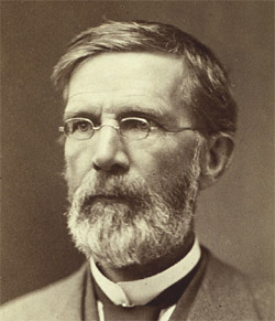
In 1867, an American geographer named George Davidson climbed the volcano. He did important research on the volcano and the Makushin valley.
Where is Makushin? The Volcano's Location and Features
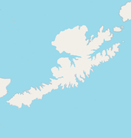
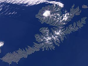
Mount Makushin is on the northern part of Unalaska Island. This island is west of the town of Dutch Harbor. Unalaska Bay, which is 10 kilometers (6.2 mi) wide, separates Dutch Harbor from Unalaska town.
The volcano itself is very wide, about 16 kilometers (9.9 mi) across. It forms the triangular northwest end of Unalaska Island. The caldera at its top is about 2.5 kilometers (1.6 mi) wide. Unlike other volcanoes in the Aleutian region, Makushin is broad and dome-shaped. It has an ice field covering 40 km2 (15 sq mi).
You can find fumaroles (steam vents) and hot springs around the volcano. These often line up in a row. About 8 kilometers (5.0 mi) south of Makushin is the "Pakushin cone." This cone has several craters and erupted 4,000 years ago. There are also rock exposures on the southeast side of the volcano, about 975 meters (3,199 ft) high.
The eruptions that formed the caldera filled valleys around the volcano with ash and rock. These deposits can be up to 100 meters (328 feet) deep. The northeast side of the volcano is also covered in volcanic lava, called the "Lava Ramp." This ramp spreads over 50 km2 (19 sq mi).
Hot springs and fumaroles are found on the east and southeast sides of the volcano. They are also at the summit and in the valleys. A valley named Makushin stretches northeast from the volcano. It was found to be a glacial valley after a survey in 1873.
The land around the volcano is very rough. However, most of it has plants growing on it. The areas covered by ash and rock flows have less plant life. You can find both short and tall grasses in the volcano area. They range from less than 20 cm (8 inches) to over 1 meter (3 feet) high.
John Muir, a famous Scottish-born American naturalist (1838–1914), wrote about Makushin. In his book "The Cruise of the Corwin (1881)," he described the volcano:
The noblest of them all was Makushin, about nine thousand feet high and laden with glaciers, a grand sight, far surpassing what I had been led to expect. There is a spot on its summit which is said to smoke, probably mostly steam and vapor from the infiltration of water into the heated cavities of the old volcano. The extreme summit of Makushin was wrapped in white clouds, and from beneath these the glaciers were seen descending impressively into the sunshine to within a thousand or fifteen hundred feet of sea-level. This fine mountain, glittering in its showy mail of snow and ice, together with a hundred other peaks dipping into the blue sky, and every one of them telling the work of ice or fire in their forms and sculpture—these, and the sparkling sea, and long inreaching fiords, are a noble picture to add to the thousand others which have enriched our lives this summer in the great Northland.
The town closest to the volcano is Unalaska. It is about 1,280 kilometers (800 mi) from Anchorage. Unalaska is located in the Aleutian Archipelago at the northern end of the island. It sits on a well-protected bay. This town was a busy center for shipping and trade when Russia controlled the area (1741–1867).
Dutch Harbor is another important harbor town across from Unalaska. It was a major naval base during World War II. Today, fishing and crabbing are the main industries that support Unalaska Island's economy.
Researching Makushin: Geothermal Energy
Scientists have studied the high-temperature geothermal resources around Makushin. These studies looked at areas in the volcano's summit caldera. They also looked at the southeastern and eastern sides of Makushin. The volcano is part of a chain of volcanoes called the Aleutian Arc.
The Alaska Power Authority has looked into using the heat from under the volcano. This geothermal energy could provide power for Unalaska town and Dutch Harbor. Their study found that generating energy from these geothermal resources would be cheaper. It would cost less than the diesel power system currently used on the island.
 | Aaron Henry |
 | T. R. M. Howard |
 | Jesse Jackson |


