Uniondale, Indiana facts for kids
Quick facts for kids
Uniondale, Indiana
|
|
|---|---|

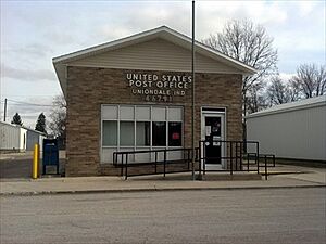
Uniondale post office in 2012
|
|

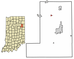
Location of Uniondale in Wells County, Indiana.
|
|
| Country | United States |
| State | Indiana |
| County | Wells |
| Township | Union, Rockcreek |
| Government | |
| • Type | Mayor-council government |
| Area | |
| • Total | 0.21 sq mi (0.55 km2) |
| • Land | 0.21 sq mi (0.54 km2) |
| • Water | 0.00 sq mi (0.01 km2) |
| Elevation | 814 ft (248 m) |
| Population
(2020)
|
|
| • Total | 271 |
| • Density | 1,290.48/sq mi (498.58/km2) |
| Time zone | UTC-5 (Eastern (EST)) |
| • Summer (DST) | UTC-4 (EDT) |
| ZIP code |
46791
|
| Area code(s) | 260 |
| FIPS code | 18-77786 |
| GNIS feature ID | 2397705 |
Uniondale is a small town located in Wells County, Indiana, in the United States. It is part of both Union and Rockcreek townships. In 2020, about 271 people lived there. This makes it a quiet place to live.
Contents
History of Uniondale
Uniondale has a simple but interesting history. The town's post office, which helps people send and receive mail, has been open since 1886. This shows that Uniondale has been a settled community for a long time.
Famous People from Uniondale
Even though Uniondale is a small town, some notable people have connections to it. These include Halie McMillan and Benjamin Stephens. They are known for their contributions, though the specific details are not widely published.
Geography and Location
Uniondale is located in the state of Indiana. It is a small town in terms of its size.
How Big is Uniondale?
According to information from 2010, Uniondale covers a total area of about 0.212 square miles (0.55 square kilometers). Most of this area is land. Only a very small part, about 0.002 square miles (0.01 square kilometers), is water. This means Uniondale is mostly dry land.
Population Information
The number of people living in Uniondale has changed over the years. Here is a look at how the population has grown and shrunk.
| Historical population | |||
|---|---|---|---|
| Census | Pop. | %± | |
| 1910 | 189 | — | |
| 1920 | 257 | 36.0% | |
| 1930 | 226 | −12.1% | |
| 1940 | 301 | 33.2% | |
| 1950 | 293 | −2.7% | |
| 1960 | 311 | 6.1% | |
| 1970 | 349 | 12.2% | |
| 1980 | 303 | −13.2% | |
| 1990 | 289 | −4.6% | |
| 2000 | 277 | −4.2% | |
| 2010 | 310 | 11.9% | |
| 2020 | 271 | −12.6% | |
| U.S. Decennial Census | |||
Uniondale's Population in 2010
In 2010, the census counted 310 people living in Uniondale. These people lived in 119 different homes. Out of these homes, 83 were families.
Population Density
The town had about 1,476 people per square mile (570 people per square kilometer). There were also 126 housing units. This means there were about 600 housing units per square mile (232 per square kilometer).
Racial Makeup of Residents
Most of the people in Uniondale in 2010 were White, making up 96.8% of the population.
- 0.3% were African American.
- 0.3% were Native American.
- 1.9% were Asian.
- 0.6% were from two or more races.
- About 1.0% of the population identified as Hispanic or Latino.
Households and Families
Out of the 119 homes, 34.5% had children under 18 living there. More than half, 55.5%, were married couples living together. Some homes, 10.1%, had a female head of household without a husband. A smaller number, 4.2%, had a male head of household without a wife. About 30.3% of homes were not families.
Many homes, 26.9%, had only one person living in them. About 7.5% of these single-person homes had someone 65 years or older. On average, each home had 2.61 people. Families, on average, had 3.13 people.
Age of Residents
The average age of people in Uniondale in 2010 was 37.4 years old.
- 25.2% of residents were under 18 years old.
- 12.3% were between 18 and 24 years old.
- 22.6% were between 25 and 44 years old.
- 27.7% were between 45 and 64 years old.
- 12.3% were 65 years or older.
The town had slightly more females (51.0%) than males (49.0%).
See also

- In Spanish: Uniondale (Indiana) para niños
 | Jessica Watkins |
 | Robert Henry Lawrence Jr. |
 | Mae Jemison |
 | Sian Proctor |
 | Guion Bluford |

