Unionville, Georgia facts for kids
Quick facts for kids
Unionville, Georgia
|
|
|---|---|

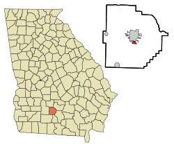
Location in Tift County and the state of Georgia
|
|
| Country | United States |
| State | Georgia |
| County | Tift |
| Area | |
| • Total | 0.75 sq mi (1.95 km2) |
| • Land | 0.75 sq mi (1.95 km2) |
| • Water | 0.00 sq mi (0.00 km2) |
| Elevation | 351 ft (107 m) |
| Population
(2020)
|
|
| • Total | 1,688 |
| • Density | 2,247.67/sq mi (867.75/km2) |
| Time zone | UTC-5 (Eastern (EST)) |
| • Summer (DST) | UTC-4 (EDT) |
| ZIP code |
31794
|
| Area code(s) | 229 |
| FIPS code | 13-78464 |
| GNIS feature ID | 0333309 |
Unionville is a community located in Tift County, Georgia, in the United States. It is known as a census-designated place (CDP). This means it's an area that the U.S. Census Bureau identifies for collecting population data, even though it doesn't have its own official city government. In 2020, about 1,688 people lived there.
Contents
History of Unionville
Unionville got its name in the 1880s. It was named after the Union Lumber Company, which was an important business in the area at that time.
Geography of Unionville
Unionville is located at coordinates 31.435302 degrees north and 83.508824 degrees west. The community covers a total area of about 0.75 square miles (1.95 square kilometers). All of this area is land, meaning there are no large bodies of water like lakes or rivers within its boundaries.
Population and Demographics
The population of Unionville has changed over the years. In 2000, there were 2,074 people living there. By 2010, the population had decreased to 1,845, and in the most recent 2020 census, it was 1,688 people.
| Historical population | |||
|---|---|---|---|
| Census | Pop. | %± | |
| 1960 | 1,607 | — | |
| 1970 | 1,646 | 2.4% | |
| 1980 | 1,942 | 18.0% | |
| 1990 | 2,710 | 39.5% | |
| 2000 | 2,074 | −23.5% | |
| 2010 | 1,845 | −11.0% | |
| 2020 | 1,688 | −8.5% | |
| U.S. Decennial Census 1850-1870 1870-1880 1890-1910 1920-1930 1940 1950 1960 1970 1980 1990 2000 2010 2020 |
|||
In the 1950s, Unionville was counted together with another community called Phillipsburg. They were considered one area with a population of 2,770 people. However, by the 1960 census, Unionville and Phillipsburg were counted separately. Unionville became a specific "census-designated place" in 1980, which helped track its population more accurately.
Racial and Ethnic Makeup
The community of Unionville is home to people from various backgrounds. According to the 2020 census, most residents (about 94.67%) identified as Black or African American. A smaller percentage (about 1.30%) identified as White. There were also people who identified as Native American, Asian, or of mixed races. About 2.07% of the population identified as Hispanic or Latino, who can be of any race.
As of 2020, there were 651 households in Unionville, and 318 of these were families.
See also
 In Spanish: Unionville (Georgia) para niños
 | Laphonza Butler |
 | Daisy Bates |
 | Elizabeth Piper Ensley |

