Unwin Radar facts for kids
The Unwin Radar is a special scientific radar system located at Awarua, near Invercargill, New Zealand 46°31′S 168°23′E / 46.51°S 168.38°E. It's like a giant ear that listens to signals from space and our atmosphere.
This radar is part of a bigger international network called Super Dual Auroral Radar Network (SuperDARN). SuperDARN uses radars all over the world to study the upper parts of our atmosphere and a layer called the ionosphere. It works by sending out radio waves in the High Frequency (HF) range, which is between 8 and 22 MHz.
The Unwin Radar helps scientists understand "space weather." This knowledge helps us with weather prediction here on Earth. It also helps predict when telecommunication signals might get interrupted. Plus, it helps us understand how Earth's magnetic fields affect power grids.
The radar facility is run by La Trobe University. It was named after Bob Unwin, a scientist who was a pioneer in studying the aurora with radar. He first thought of this project back in the 1960s.
Contents
How the Unwin Radar Works
The Unwin Radar sends out quick bursts of shortwave radio pulses. These pulses travel in a southern arc, reaching towards the South Magnetic Pole. When these radio waves hit things like tiny space rocks (called micrometeorites), the ionosphere, the ocean, or the aurora, they bounce back.
The radar station then detects these reflections. By studying the bounced-back signals, scientists can figure out what's happening far away.
Radar Design and Operation
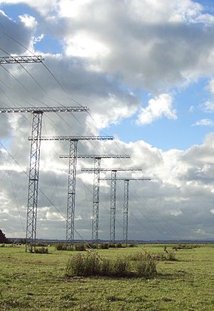
The TIGER-Unwin is a special type of radar called a monostatic, pulsed radar. It operates in the 8 MHz to 20 MHz range. The part that sends out signals, called the transmitting antenna, has 16 long, thin antennas.
- These antennas create a narrow radio beam, about 4 degrees wide (at 12 MHz).
- This beam sweeps across the area the radar is watching in 16 steps.
- Vertically, the beam is about 30 degrees wide. Its strongest point is between 15 degrees (at 20 MHz) and 35 degrees (at 8 MHz) above the horizon.
There are also four extra antennas located behind the main transmitting antennas. These are used to help measure the exact height or angle of the signals that bounce back. This is called measuring the "elevation angle of echoes."
Smart Frequency Hopping
In its normal way of working, the radar uses something called frequency hopping. This means the radar changes its transmission frequency often. It does this to adapt to changing conditions in the ionosphere.
The radar constantly scans the frequency band. It automatically finds channels that are clear of interference. This helps it get the best possible coverage and clearest signals.
Data and Connections
The information collected by the Unwin Radar is sent back to La Trobe University. From there, it is shared online with scientists all over the world. The Unwin Radar works together with another radar on Bruny Island in Tasmania. Together, they form the Tasman International Geospace Environment Radar (TIGER).
The Southland region in New Zealand is a perfect spot for this radar. It faces south, has very little radio noise, and has a clear view of the horizon.
 | Dorothy Vaughan |
 | Charles Henry Turner |
 | Hildrus Poindexter |
 | Henry Cecil McBay |


