Upper Colorado water resource region facts for kids
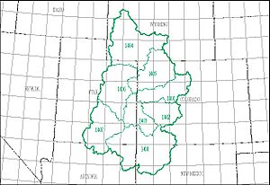
The Upper Colorado water resource region is a big area of land in the western United States. It's one of 21 main areas that the United States Geological Survey (USGS) uses to study water. Think of it like dividing a big map into smaller sections to understand how water flows.
These areas, called water regions, usually include all the land where water drains into a major river. Or, they might include several rivers that flow together. The Upper Colorado region is special because it's where the famous Colorado River starts and flows for a long way.
This region has a special code, 14, and it's huge! It covers about 113,347 square miles (293,540 km2). It's made up of 8 smaller parts, called subregions, each with its own code from 1401 to 1408.
The Upper Colorado region includes:
- The area where the Colorado River and its branches flow, especially the part above a spot called Lee Ferry.
- A special area called the Great Divide closed basin, where water doesn't flow out to the ocean.
This important water region stretches across parts of Arizona, Colorado, New Mexico, Utah, and Wyoming.
What is a Water Resource Region?
Imagine all the rain and snow that falls on land. It eventually flows into streams, rivers, and lakes. A water resource region is like a giant bowl that catches all this water. It includes all the land that drains into a specific river system. Scientists use these regions to manage water and understand how it moves across the country.
Exploring the Upper Colorado Subregions
The Upper Colorado water region is divided into 8 smaller parts, each with its own unique features. These subregions help scientists study and manage the water more closely. Here’s a look at each one:
 | James Van Der Zee |
 | Alma Thomas |
 | Ellis Wilson |
 | Margaret Taylor-Burroughs |


