Upper Mesa Falls facts for kids
Quick facts for kids Upper Mesa Falls |
|
|---|---|

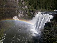
Upper Mesa Falls in June, 2008
|
|
| Lua error in Module:Infobox_mapframe at line 185: attempt to index field 'wikibase' (a nil value). | |
| Location | Fremont County, Idaho |
| Coordinates | 44°11′16″N 111°19′48″W / 44.18778°N 111.33000°W |
| Type | Block |
| Elevation | 5,600 feet (1,707 m) |
| Total height | 114 feet (35 m) |
| Watercourse | Henrys Fork (Snake River) |
Upper Mesa Falls is an amazing waterfall located in the Caribou-Targhee National Forest. It's found on the Henrys Fork river. This beautiful waterfall is about 114 feet (35 meters) tall. It is also around 200 feet (61 meters) wide. You can find it about 16 miles (26 km) from Ashton, Idaho. It's also upstream from another waterfall called Lower Mesa Falls.
How Upper Mesa Falls Was Formed
Ancient Volcanoes and Rock Layers
The rock that Upper Mesa Falls flows over is called Mesa Falls Tuff. This special rock was created about 1.3 million years ago. Back then, there was a lot of volcanic activity in the area. A huge volcano, called the Henrys Fork caldera, erupted. It sent out thick layers of rock and ash. Over a very long time, these layers pressed together. They became hard rock, forming the Mesa Falls Tuff.
River Carving the Canyon
Later, between 200,000 and 600,000 years ago, the Henrys Fork river started to carve a wide canyon. After a while, basalt lava flowed into this canyon. Basalt is a type of dark, hard volcanic rock. This lava partly filled the canyon. Then, the Henrys Fork river continued its work. It cut through the basalt rock. This created the inner canyon you can see today. The waterfall now cascades over these ancient layers of rock.
 | Charles R. Drew |
 | Benjamin Banneker |
 | Jane C. Wright |
 | Roger Arliner Young |

