Uri, Sardinia facts for kids
Quick facts for kids
Uri
|
|
|---|---|
| Comune di Uri | |
 |
|
| Country | Italy |
| Region | Sardinia |
| Province | Province of Sassari (SS) |
| Area | |
| • Total | 56.7 km2 (21.9 sq mi) |
| Elevation | 150 m (490 ft) |
| Population
(Dec. 2004)
|
|
| • Total | 3,040 |
| • Density | 53.62/km2 (138.9/sq mi) |
| Demonym(s) | Uresi |
| Time zone | UTC+1 (CET) |
| • Summer (DST) | UTC+2 (CEST) |
| Postal code |
07040
|
| Dialing code | +390794198700 |
| Patron saint | Ns di Paulis |
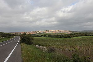
Uri is a small town, also called a comune (which means municipality or local area), in the Province of Sassari. This province is part of the Italian region of Sardinia. Uri is located about 18 kilometers (11 miles) from Alghero and its airport. It's also about 12 kilometers (7.5 miles) northwest of Sassari. The capital city of Sardinia, Cagliari, is about 170 kilometers (106 miles) away.
Uri is famous for its special artichoke festival. This fun event happens every year in March. In December 2004, about 3,040 people lived in Uri, and the town covered an area of 56.7 square kilometers (21.9 square miles).
Contents
Where is Uri Located?
Uri shares its borders with several other towns. These include Alghero, Ittiri, Olmedo, Putifigari, Sassari, and Usini. It's nestled in a beautiful part of Sardinia.
Uri's Past: A Look at History
Uri has a very long and interesting history. People have lived in this area for thousands of years!
Ancient Times in Uri
The very first signs of people living in Uri date back to around 3000 BC. These early homes were carved into rocks and are called Domus de janas, which means "fairy houses." Later, the ancient Romans also came to this area and made it part of their empire.
Uri in the Middle Ages
After the big fall of the Western Roman Empire, Sardinia was ruled by different groups. First, the Vandals took control, and then the Byzantines. During this time, there was a mix of cultures. Some people followed Roman and Christian ways, while others still held onto older, traditional beliefs. We know this from letters written by Pope Gregory I, an important leader of the Christian church.
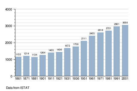
How Uri's Population Changed
The number of people living in Uri has changed a lot over the years. This timeline shows how the population grew and shrank at different times.

Important Places to See in Uri
Uri is home to several old churches and interesting archaeological sites. These places tell us more about the town's past.
- Nostra Signora della Pazienza Church XVI sc. (This church was built in the 16th century.)
- Santa Croce Church XII sc. (This church dates back to the 12th century.)
- St.Catherine archaeological site (An ancient site where people can explore history.)
- Paulis abbey ruins XI sc. (The remains of an old abbey from the 11th century.)
- San Leonardo Church, XI sc. (Another church from the 11th century.)
- Santu Pedru Necropolis (An ancient burial ground.)
Getting Around Uri
Uri is easy to reach by air and sea.
- The closest airport is Alghero-Fertilia International Airport. It's about 25 kilometers (15.5 miles) from Uri.
- If you travel by sea, the nearest port is Porto Torres, which is about 28 kilometers (17.4 miles) away.
- Uri is connected to Alghero by the SS127bis freeway and to Sassari by the Sp15m freeway.
See also
 In Spanish: Uri (Italia) para niños
 | Kyle Baker |
 | Joseph Yoakum |
 | Laura Wheeler Waring |
 | Henry Ossawa Tanner |

