Utah State Route 190 facts for kids
Quick facts for kids
State Route 190 |
||||
|---|---|---|---|---|
| Big Cottonwood Canyon Scenic Byway | ||||
| Lua error in Module:Infobox_road/map at line 15: attempt to index field 'wikibase' (a nil value). | ||||
| Route information | ||||
| Defined by Utah Code §72-4-124 | ||||
| Maintained by UDOT | ||||
| Length | 19.934 mi (32.081 km) | |||
| Existed | 1987–present | |||
| Restrictions | Closed in winter over Guardsman Pass | |||
| Major junctions | ||||
| West end | ||||
| East end | Salt Lake County/Wasatch County line | |||
| Highway system | ||||
| State highways in Utah Interstate • US • State
|
||||
State Route 190, also known as the Big Cottonwood Canyon Scenic Byway, is a beautiful road in Salt Lake County, Utah. It mostly runs from west to east. This scenic highway starts near I-215 and winds its way through the amazing Big Cottonwood Canyon. It even includes a loop through the Brighton area. The road ends at the border between Salt Lake County and Wasatch County.
Contents
Exploring State Route 190
Starting in Holladay and Cottonwood Heights
State Route 190 (SR-190) begins at a special exit from I-215. As you start your journey, the road gently curves south. It climbs up from the lower areas of Holladay, near the Big Cottonwood Creek.
First, the road runs along the base of the mountainside. To your north, you'll see Mount Olympus. Then, it follows a mountainside that faces west, just before the entrance to Big Cottonwood Canyon. The border between the cities of Holladay and Cottonwood Heights follows this road for a while.
Near Wasatch Boulevard, you'll pass office buildings and the Old Mill Golf Course. There's also a Utah Transit Authority park-and-ride lot. This is a place where people can park their cars and take a bus. South of Wasatch Boulevard, SR-190 actually takes on the name Wasatch Boulevard. Here, you'll see a quarry to the east. You can also enjoy views of the valley below to the west. Hidden from sight, at the bottom of a cliff, is the old paper mill building. This area is often known for that historic mill.
The road continues south, crossing over a bridge. This bridge goes over Big Cottonwood Creek. It also crosses a planned walking and biking path along the creek. Then, SR-190 meets SR-210. SR-210 continues south as Wasatch Boulevard. Another road, Fort Union Boulevard, heads west from this intersection. If you want to stay on SR-190 heading east, you need to turn left here. After this turn, you'll see more park-and-ride lots. These are mainly used for ski buses in winter. A water treatment plant is also visible to the north. On the south side, you'll see homes in Cottonwood Heights.
Journey Through Big Cottonwood Canyon
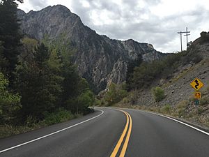
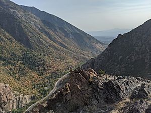
As you drive deeper into the canyon, the city buildings quickly disappear. The canyon walls get closer together, making you feel surrounded by nature. Along the way, SR-190 passes many trailheads. These are starting points for hiking trails. You'll also see picnic areas where families can stop and eat.
The canyon is rich in history. You'll notice old structures related to water and mining. There are also a few areas with cabins, which are small homes. As you continue, you'll pass Solitude Mountain Resort. This is a popular place for skiing and other mountain activities. The road then loops through Brighton, another well-known ski area.
Reaching Guardsman Pass
After going through Brighton, SR-190 connects to a narrower mountain road. This road crosses over Guardsman Pass. The state-maintained part of SR-190 ends at the top of this pass. From here, a non-state road continues into Wasatch County. This road can take you to Park City (via SR-224) or to Midway and Heber City (via SR-222). It's important to know that this part of the road is usually closed during the winter months due to snow.
How State Route 190 Was Created
The story of SR-190 began in 1933. At that time, a part of what is now SR-190 was part of another road called SR-152. SR-152 went from Salt Lake City into Big Cottonwood Canyon.
In 1941, SR-152 was made longer, reaching all the way to Brighton. A few years later, in 1945, the connection from Highland Drive to the canyon was moved south to Fort Union Boulevard. To help people get to the new Wasatch Mountain State Park, SR-152 was extended even further in 1963. It followed an existing county road over Guardsman Pass and ended at SR-224.
Finally, in 1987, some changes were made. A section of SR-152 was removed from the state highway system. In its place, a new road was planned. This new road became an extension of SR-210. The old part of SR-152, from Wasatch Boulevard to SR-224, became the new State Route 190.
In 1988, the new connection also became part of SR-190. This made SR-190 stretch from I-215 all the way to SR-224. However, in 1990, the eastern end of SR-190 was shortened. It now ends at the border between Salt Lake and Wasatch County. This change was part of a trade with Wasatch County.
Where Roads Meet: Major Intersections
Here are the main places where State Route 190 connects with other important roads: The entire route is in Salt Lake County.
| Location | Mile | Roads intersected | Notes | |
|---|---|---|---|---|
| Holladay | 0.000 | 0.000 | This is the very beginning of SR-190 on the west side. 40°38′13″N 111°48′28″W / 40.63694°N 111.80778°W | |
| Cottonwood Heights | 1.830 | 2.945 | SR-210 | |
| | 19.934 | 32.081 | County line | This is where SR-190 ends on the east side, at the county border. 40°36′24″N 111°33′18″W / 40.60667°N 111.55500°W |
| 1.000 mi = 1.609 km; 1.000 km = 0.621 mi | ||||
 | Victor J. Glover |
 | Yvonne Cagle |
 | Jeanette Epps |
 | Bernard A. Harris Jr. |


