Utena County facts for kids
Quick facts for kids
Utena county
Utenos apskritis
|
|||
|---|---|---|---|
|
County
|
|||
 |
|||
|
|||

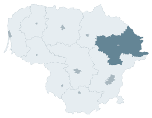
Location of Utena County
|
|||
| Country | |||
| Administrative centre | Utena | ||
| Municipalities |
List
Anykščiai district municipality
Ignalina district municipality Molėtai district municipality Utena district municipality Visaginas municipality Zarasai district municipality |
||
| Area | |||
| • Total | 7,201 km2 (2,780 sq mi) | ||
| (11% of the area of Lithuania) | |||
| Population
(2016-01-20)
|
|||
| • Total | 137,260 ([1]) | ||
| • Rank | 9th of 10 (5.0% of the population of Lithuania) | ||
| Time zone | UTC+2 (EET) | ||
| • Summer (DST) | UTC+3 (EEST) | ||
| ISO 3166 code | LT-UT | ||
| GDP (nominal) | 2017 | ||
| - Total | €1.2($1.4) billion | ||
| - Per capita | €9,100($10,300) ([2]) | ||
| HDI (2017) | 0.815 very high · 8th |
||
Utena County (Lithuanian: Utenos Apskritis) is one of the 10 counties in Lithuania. A county is like a large region or district. The main city and capital of Utena County is Utena. This county covers about 11% of Lithuania's total area.
Contents
Local Government: Municipalities
Utena County is divided into six smaller areas called municipalities. Each municipality has its own local government. These areas help manage services and daily life for the people living there.
Understanding Municipalities
Municipalities are like local towns or districts. They have their own councils and leaders. These local groups make decisions about things like schools, roads, and public services.
List of Municipalities
Here are the six municipalities that make up Utena County:
| Anykščiai District Municipality | |
| Ignalina District Municipality | |
| Molėtai District Municipality | |
| Utena District Municipality | |
| Visaginas Municipality | |
| Zarasai District Municipality |
See also
 In Spanish: Provincia de Utena para niños
Black History Month on Kiddle
Outstanding African-American Women
 | Jewel Prestage |
 | Ella Baker |
 | Fannie Lou Hamer |

All content from Kiddle encyclopedia articles (including the article images and facts) can be freely used under Attribution-ShareAlike license, unless stated otherwise. Cite this article:
Utena County Facts for Kids. Kiddle Encyclopedia.


