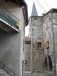
Uzer, Ardèche facts for kids
Quick facts for kids
Uzer
|
|
|---|---|
 |
|
| Country | France |
| Region | Auvergne-Rhône-Alpes |
| Department | Ardèche |
| Arrondissement | Largentière |
| Canton | Largentière |
| Intercommunality | Val de Ligne |
| Area
1
|
3.51 km2 (1.36 sq mi) |
| Population
(1999)
|
336 |
| • Density | 95.73/km2 (247.9/sq mi) |
| Time zone | UTC+01:00 (CET) |
| • Summer (DST) | UTC+02:00 (CEST) |
| INSEE/Postal code |
07327 /07110
|
| Elevation | 130–335 m (427–1,099 ft) (avg. 146 m or 479 ft) |
| 1 French Land Register data, which excludes lakes, ponds, glaciers > 1 km2 (0.386 sq mi or 247 acres) and river estuaries. | |
Uzer is a small town, also known as a commune, located in the Ardèche area of southern France. It is part of the département of Ardèche, which is like a county or region in France.
About Uzer
Uzer is a charming place in the beautiful Ardèche region. It is known for its quiet atmosphere and natural surroundings. The village is nestled among hills and valleys, offering lovely views.
Where is Uzer?
Uzer is found in the southern part of France. It is in the Ardèche département, which is famous for its stunning landscapes, including rivers, gorges, and mountains. The village is located near the town of Largentière.
People and Government
In 1999, Uzer had a population of 336 people. This means it is a very small community. Like all communes in France, Uzer has a mayor who helps run the town. From 2001 to 2008, the mayor was Jean-Claude Moretto. The commune is also part of a group of towns called Val de Ligne, which work together on different projects.
Geography and Nature
Uzer covers an area of about 3.51 square kilometers. The land in Uzer varies in height. The lowest point is 130 meters above sea level, and the highest point is 335 meters. The average height of the commune is 146 meters. This varied landscape means there are different types of plants and animals that call Uzer home.
See also

- In Spanish: Uzer (Ardèche) para niños


