
Vaigai River facts for kids
Quick facts for kids Vaigai River (வைகை ஆறு) |
|
| River | |
| Country | India |
|---|---|
| Source | Varusanadu Hills |
| - location | Tamil Nadu, India |
| Mouth | |
| - location | Palk Strait, India |
| - elevation | 0 m (0 ft) |
| Length | 258 km (160 mi) |
| Discharge | |
| - average | 36 m³/s (1,271 cu ft/s) |
| Discharge elsewhere (average) | |
| - Peranai | 28.8 m³/s (1,017 cu ft/s) |
The Vaigai River is an important river in Tamil Nadu, India. It begins its journey in the Varusanadu Hills, which are part of the Western Ghats. This river flows east across the state, passing by the famous city of Madurai. Eventually, the Vaigai River flows into the Palk Strait, near the Ramanathapuram district. The river also creates the beautiful Vattaparai Falls.

How Long is the Vaigai River?
The Vaigai River stretches for about 256 kilometers (160 miles). The total area that collects water for the Vaigai River, known as its drainage basin, covers 7,036 square kilometers.
Rivers That Join the Vaigai
Many smaller rivers, called tributaries, flow into the Vaigai River. Some of these include the Suruli River, Mullaiyaar River, Varaha River, and Manjal River. The Kirudhumal River also joins the Vaigai River in the Theni district. Interestingly, water from the Periyar River is sometimes redirected to flow into the Vaigai River, helping to keep it full.
Images for kids
-
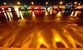
Vaigai River at night

See also
 In Spanish: Río Vaigai para niños
