Vandling, Pennsylvania facts for kids
Quick facts for kids
Vandling, Pennsylvania
|
|
|---|---|
|
Borough
|
|

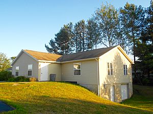
Vandling Municipal Complex
|
|

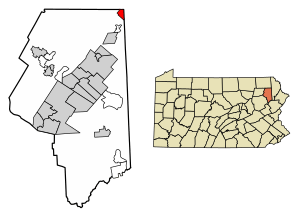
Location in Lackawanna County, Pennsylvania
|
|
| Country | United States |
| State | Pennsylvania |
| County | Lackawanna |
| Area | |
| • Total | 1.31 sq mi (3.40 km2) |
| • Land | 1.31 sq mi (3.40 km2) |
| • Water | 0.00 sq mi (0.00 km2) |
| Elevation | 1,365 ft (416 m) |
| Population
(2020)
|
|
| • Total | 730 |
| • Estimate
(2021)
|
728 |
| • Density | 536.94/sq mi (207.34/km2) |
| Time zone | UTC-5 (EST) |
| • Summer (DST) | UTC-4 (EDT) |
| Zip Code |
18421
|
| Area code(s) | 570 |
| FIPS code | 42-79792 |
Vandling is a small town, also called a borough, located in the northeastern part of Lackawanna County, Pennsylvania. In 2020, about 730 people lived there. It's just south of a bigger town called Forest City.
Contents
Understanding Vandling's Location
Vandling is found at specific coordinates: 41.633771 degrees North and 75.469578 degrees West. This helps us pinpoint its exact spot on a map.
Land Area of Vandling
The United States Census Bureau tells us that Vandling covers a total area of about 3.4 square kilometers (which is about 1.31 square miles). All of this area is land, meaning there are no large lakes or rivers within the borough's official borders.
Who Lives in Vandling?
The number of people living in Vandling has changed over the years. Here's a quick look at the population counts from different years:
|
||||||||||||||||||||||||||||||||||||||||||||||||||||||||||||||||||||
Population Details from 2010
In 2010, there were 751 people living in Vandling. These people lived in 309 different homes, and 203 of these were families. The town had about 577 people per square mile. There were also 340 housing units available.
Most people in Vandling were White (96%). A smaller number were Black (1.3%), American Indian (0.7%), or Asian (0.3%). Some people were from other backgrounds or a mix of two or more races. About 2.1% of the population identified as Hispanic or Latino.
Households and Families
Out of the 309 homes in Vandling, about 27.5% had children under 18 living there. More than half (51.8%) were married couples living together. About 10.7% of homes had a female head of household without a husband present. About 34.3% of homes were not families.
Roughly 27.2% of all homes had just one person living there. About 13.6% of homes had someone living alone who was 65 years old or older. On average, each home had about 2.43 people, and each family had about 2.95 people.
Age Groups in Vandling
The population of Vandling is spread out across different age groups. About 22.2% of the people were under 18 years old. The largest group, 60.4%, were adults aged 18 to 64. About 17.4% of the population were 65 years old or older. The average age in Vandling was 42.5 years.
Income and Economy
In 2010, the average income for a household in Vandling was $37,212 per year. For families, the average income was $46,250. Men earned about $32,250 on average, while women earned about $24,444. The average income per person in the borough was $18,748.
About 3.4% of families and 5.6% of all people in Vandling lived below the poverty line. This included 6.3% of those under 18 and 6.5% of those aged 65 or older.
Education in Vandling
Students living in Vandling attend schools that are part of the Forest City Regional School District. This school district provides education from preschool all the way through 12th grade.
See also
 In Spanish: Vandling para niños
 | Janet Taylor Pickett |
 | Synthia Saint James |
 | Howardena Pindell |
 | Faith Ringgold |


