Varanus Island facts for kids

Varanus Island off Western Australia
|
|
| Geography | |
|---|---|
| Location | Indian Ocean, off the coast of Western Australia |
| Coordinates | 20°39′3″S 115°34′27″E / 20.65083°S 115.57417°E |
| Archipelago | Lowendal Islands |
| Area | 0.83 km2 (0.32 sq mi) |
| Length | 2.5 km (1.55 mi) |
| Width | 0.6 km (0.37 mi) |
| Administration | |
|
Australia
|
|
| State | Western Australia |
Varanus Island is the biggest island in the Lowendal Islands. This group of islands, called an archipelago, is found off the northwest coast of Western Australia. It is located near the town of Karratha in the Pilbara region.
The island is about 59 kilometers (37 miles) away from the mainland coast. You can find it at these coordinates: 20°39′3″S 115°34′27″E / 20.65083°S 115.57417°E.
What Varanus Island Does
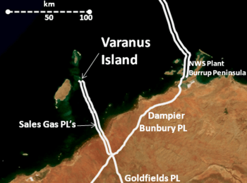
Varanus Island is an important place for energy. It has special equipment to move oil and gas. This oil and gas comes from areas like the Harriet and East Spar oilfields.
The island's main job is to process these fuels. It is known as the Varanus Island Processing Hub. This hub is currently owned by a company called Santos Limited.
Wildlife and Nature
Varanus Island is a special home for many birds. It is part of the Lowendal Islands Important Bird Area. This means it's a very important spot for seabirds to breed and raise their young.
Organizations like BirdLife International have recognized its importance. Even with the oil and gas operations, the birds living on the island seem to be doing well.
The 2008 Gas Incident
In 2008, something unexpected happened on the island. On June 3, a main gas pipeline belonging to Apache Energy had a problem. This caused the plant to shut down completely.
All the workers on the island were safely taken off. The shutdown meant that Western Australia's gas supply was cut by about one-third. This led to an energy shortage for homes and businesses. Apache Energy worked hard to fix the issue. They expected it would take a few months to get the plant working even partly again.

