Vermillon River (La Tuque) facts for kids
Quick facts for kids Vermillon River |
|
|---|---|
 |
|
 |
|
| Country | |
| Province | |
| Region | Mauricie |
| Physical characteristics | |
| Main source | Lake Launay MRC Matawinie, Lanaudière 236 m (774 ft) 48°21′15″N 74°06′00″W / 48.35417°N 74.10000°W |
| River mouth | Saint-Maurice River La Tuque (urban agglomeration) 47°38′43″N 72°56′41″W / 47.64528°N 72.94472°W |
| Length | 160 km (99 mi) |
| Basin features | |
| Basin size | 2,670 km2 (1,030 sq mi) |
The Vermillon River is a beautiful river located in Quebec, Canada. Its name in the Atikamekw language is acopekihikan sipi. This means "where we paddle quickly." The river flows through the area of La Tuque (urban agglomeration) in the Upper-Mauricie region.
Contents
Journey of the Vermillon River
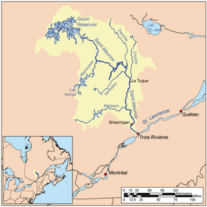
The Vermillon River is about 160 kilometers (100 miles) long. It flows mostly east before joining the Saint-Maurice River. The Saint-Maurice River is a much larger river. The Vermillon River meets it on its west bank. This meeting point is about 23 kilometers (14 miles) north of the Beaumont dam. It is also about 20 kilometers (12 miles) south of the Rapide-Blanc dam. The Vermillon River is one of the biggest rivers that flows into the Saint-Maurice River. Other important rivers that join the Saint-Maurice include the Matawin, Manouane, Trenche, and La Croche.
Where Does the River Start?
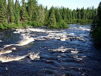
The Vermillon River begins at Lake Launay. This lake is found in the northwest part of the Galifet township. As the water flows from Lake Launay, it travels through many exciting parts. It goes over rapids and waterfalls. Sometimes, it takes a winding path through different areas. These areas include the townships of Galifet, The Pottery, Dupuis, and Picard.
The River's Path
Near the "Lac Brûlé" (Burned Lake) dam, the Vermillon River changes direction. It turns towards the northeast. It then flows through the Bisaillon, Olscamps, and Payment townships. Finally, it reaches its mouth where it joins the Saint-Maurice River. The river's journey includes flowing southeast first. Then, it travels 51.3 kilometers (31.9 miles) to the northeast. For its last 8.5 kilometers (5.3 miles), it makes a sharp turn and flows east to its end.
Why is it Called Vermillon?
The name "Vermillon" is very interesting. It comes from the word "vermilion," which is a bright, yellowish-red color. There is a dam called "Vermillon - Two dam" near the railway stop of Rapide-Blanc, Quebec. This name also refers to two lakes and a small river in the same area.
Indigenous Connections to the Name
Some people think the name "Vermillon" might be a French translation of an old Indigenous name. Long ago, Indigenous people sometimes painted their bodies with colorful chalk. This could have included bright red colors.
In 1824, an explorer named Francis Verreault mentioned the "Raman (Vermilion) River." Also, the Romaine River in the Côte-Nord region was once called "Ouramane" or "Olomane." These names also meant "vermilion."
A merchant named Jean-Baptiste Perrault wrote about the "Vermillon River" in his travel notes around 1830. The Abenaki people had their own name for the river: Azobakhigan. This means "Where we paddle quickly." The Atikamekw people called it Kanimepirikaci Matawa, which means "tributary of Lake carp."
The name "Vermillon River" was officially recorded on December 5, 1968. This was done by the Commission de toponymie du Québec, which is like a board that names places in Quebec.
A Brief History of the Vermillon River Area
The area around the Vermillon River has a rich history. It involves Indigenous peoples and European settlers.
Early European Arrivals
In 1651, the first Europeans arrived in the Atikamekw territory. They were Catholic missionaries, like Father Jacques Buteux. He was one of the first Jesuit missionaries in the region. About 550 Indigenous people lived along the shores of the Saint-Maurice River at that time.
Fur Trading and Conflicts
By the late 1700s, the Atikamekw people faced challenges. They were at war with the Iroquois and suffered from diseases like smallpox. This caused their population to greatly decrease. These nomadic people often visited trading posts. These posts were set up by companies like the Hudson's Bay Company.
By 1680, the fur trade was growing. Many European traders came to the land. The North West Company and the Hudson's Bay Company became very active. They often traded in ways that were not fair to the Indigenous people. Trading posts were built in places like Rivière aux Rats (Mauricie) in La Tuque, on the Vermillon River, and in Parent and Wemotaci.
Forestry and Settlement
In the mid-1800s, new changes came to the Upper-Mauricie region. The forestry industry began to grow. This led to more non-Indigenous people settling in the area.
 | Jackie Robinson |
 | Jack Johnson |
 | Althea Gibson |
 | Arthur Ashe |
 | Muhammad Ali |

