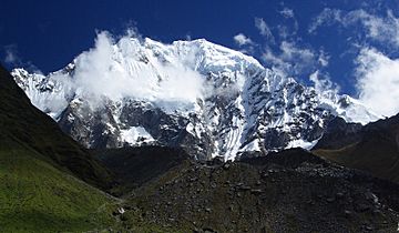
Vilcabamba mountain range facts for kids
Quick facts for kids Vilcabamba mountain range |
|
|---|---|

Salcantay
|
|
| Highest point | |
| Peak | Salcantay |
| Elevation | 6,271 m (20,574 ft) |
| Dimensions | |
| Length | 85 km (53 mi) N-S |
| Naming | |
| Native name | Error {{native name}}: an IETF language tag as parameter {{{1}}} is required (help) |
| Geography | |
| Country | Peru |
| State/Province | Cusco Region |
| Parent range | Andes |
The Vilcabamba mountain range is a group of tall mountains in the Cusco Region of Peru. It stretches for about 85 kilometers (53 miles) across different areas like Anta, La Convención, and Urubamba. The very highest point in this range is a mountain called Salcantay, which stands incredibly tall at 6,271 meters (20,574 feet) above the sea.
What Does "Vilcabamba" Mean?
The name Vilcabamba likely comes from two local languages: Aymara and Quechua. In these languages, willka can mean a type of tree or even a local god. The word pampa means a flat area or a plain. So, the name could mean "plain of the willka tree" or "plain of the god."
Amazing Mountains of Vilcabamba
The tallest mountain in the Vilcabamba range is Salcantay, reaching a height of 6,271 meters (20,574 feet). But there are many other impressive peaks in this area too!
Here are some of the other notable mountains:
- Pumasillo, 5,991 m (19,656 ft)
- Tucarhuay, 5,928 m (19,449 ft)
- Padreyoc, 5,771 m (18,934 ft)
- Panta, 5,667 m (18,593 ft)
- Choquetacarpo, 5,520 m (18,110 ft)
- Humantay, 5,473 m (17,956 ft)
- Huayanay, 5,464 m (17,927 ft)
- Pucapuca, 5,450 m (17,881 ft)
- Soray, 5,428 m (17,808 ft)
- Paljay, 5,422 m (17,789 ft)
- Amparay, 5,418 m (17,776 ft)
- Corihuayrachina, 5,404 m (17,730 ft)
- Yanama, 5,347 m (17,543 ft)
- Jatunjasa, 5,338 m (17,513 ft)
- Soirococha, 5,297 m (17,379 ft)
- Azulcocha, 5,269 m (17,287 ft)
- Kaiko, 5,265 m (17,274 ft)
- Chaupimayo, 5,239 m (17,188 ft)
- Paccha, 5,210 m (17,093 ft)
- Coisopacana, 5,176 m (16,982 ft)
- Moyoc, 5,175 m (16,978 ft)
- Choquesafra, 5,152 m (16,903 ft)
- Ocobamba, 5,126 m (16,818 ft)
- Cayco, 5,108 m (16,759 ft)
- Pumasillo, 5,100 m (16,700 ft)
- Yanajaja, 5,093 m (16,710 ft)
- Pitupaccha, 5,082 m (16,673 ft)
- Nañuhuaico, 4,932 m (16,181 ft)
- Yanacocha, 4,920 m (16,140 ft)
- Quenuaorco, 4,900 m (16,100 ft)
- Chuchaujasa, 4,800 m (15,700 ft)
- Mandorcasa, 4,800 m (15,700 ft)
- Llamahuasi, 4,728 m (15,512 ft)
- Jatun Huamanripa, 4,601 m (15,095 ft)
- Qiwiñayuq, 4,547 m (14,918 ft)
- Khallkaqucha, 4,464 m (14,646 ft)
- Yanaorjo, 4,460 m (14,630 ft)
- Yanama, 4,415 m (14,485 ft)
- Incahuasi, 4,315 m (14,157 ft)
See also
 In Spanish: Cordillera de Vilcabamba para niños
 | Ernest Everett Just |
 | Mary Jackson |
 | Emmett Chappelle |
 | Marie Maynard Daly |

