Villasimius facts for kids
Quick facts for kids
Villasimius
Crabonaxa (Sardinian)
|
||
|---|---|---|
| Comune di Villasimius | ||
 |
||
|
||
| Country | Italy | |
| Region | Sardinia | |
| Province | South Sardinia | |
| Area | ||
| • Total | 58.2 km2 (22.5 sq mi) | |
| Elevation | 41 m (135 ft) | |
| Population
(30 November 2017)
|
||
| • Total | 3,710 | |
| • Density | 63.75/km2 (165.1/sq mi) | |
| Demonym(s) | Villasimiesi | |
| Time zone | UTC+1 (CET) | |
| • Summer (DST) | UTC+2 (CEST) | |
| Postal code |
09049
|
|
| Dialing code | 070 | |
| Patron saint | Saint Raphael | |
| Saint day | 24 October | |
Villasimius is a town in the Province of South Sardinia in Sardinia, Italy. It is located about 35 kilometers (22 miles) east of Cagliari. Villasimius is also known by its Sardinian name, Crabonaxa.
Contents
A Look Back: History of Villasimius
Villasimius has been an important place for a very long time. People lived here even before recorded history. This is because of its great location.
Ancient Times
We know people lived here thanks to old buildings and items found.
- Nuraghe: These are ancient stone towers built between the 19th and 6th centuries BC. They show that people were here a very long time ago.
- Phoenicians and Carthaginians: From the 7th to the 2nd centuries BC, people from Phoenicia and Carthage lived here. They were great traders and sailors.
- Romans: The Romans were here from the 3rd century BC to the 6th century AD. They built roads and towns.
Middle Ages and Beyond
During the time of the Sardinian kingdoms, called giudicati, and later under Spanish rule, the area faced many attacks. Pirates often raided the coast. Because of these attacks, many people left, and the area became less populated.
The village was known as Carbonara from at least the 13th century. In the early 1800s, under the Kingdom of Sardinia-Piedmont, people started moving back. Villasimius officially became a comune (a type of municipality or town) in 1838.
From Farming to Fun
For a long time, the people of Villasimius mostly worked in farming and raising sheep. From 1875, they also started mining granite. However, everything changed in the late 1960s. That's when tourism began to grow. Today, tourism is the most important part of Villasimius's economy. Many people visit for its beautiful beaches and clear waters.
Exploring Villasimius: Main Sights
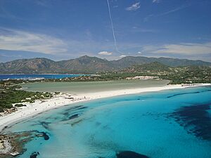
Villasimius is famous for its stunning natural beauty. Many visitors come to enjoy the sun and sea.
Beautiful Beaches
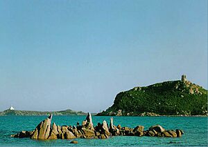
The area around Villasimius has some truly amazing beaches. They are perfect for swimming, sunbathing, and enjoying the ocean. Some of the most popular beaches include:
- Cala Burroni
- Cala Caterina
- Campus
- Piscadeddus
- Porto Giunco
- Porto Sa Ruxi
- Punta Molentis
- Simius
- Spiaggia del Riso
- Timi Ama
Capo Carbonara National Marine Park
In 1998, the Capo Carbonara National Marine Park was created. This special area protects the waters around the headlands (land that sticks out into the sea) in the eastern Gulf of Cagliari. It stretches from Villasimius's western border with Solanas to its northern border with Castiadas. This park helps protect the amazing sea life and underwater environments.
See also
 In Spanish: Villasimius para niños
 | Jessica Watkins |
 | Robert Henry Lawrence Jr. |
 | Mae Jemison |
 | Sian Proctor |
 | Guion Bluford |


