
Villiers-sur-Tholon facts for kids
Quick facts for kids
Villiers-sur-Tholon
|
||
|---|---|---|
|
Part of Montholon
|
||
 |
||
|
||

Villiers-sur-Tholon
Location in France

Villiers-sur-Tholon
Location in Bourgogne-Franche-Comté
|
||
| Country | France | |
| Region | Bourgogne-Franche-Comté | |
| Department | Yonne | |
| Arrondissement | Auxerre | |
| Canton | Charny | |
| Commune | Montholon | |
| Area
1
|
15.50 km2 (5.98 sq mi) | |
| Population
(2017)
|
469 | |
| • Density | 30.26/km2 (78.37/sq mi) | |
| Time zone | UTC+01:00 (CET) | |
| • Summer (DST) | UTC+02:00 (CEST) | |
| Postal code |
89110
|
|
| Elevation | 104–236 m (341–774 ft) | |
| 1 French Land Register data, which excludes lakes, ponds, glaciers > 1 km2 (0.386 sq mi or 247 acres) and river estuaries. | ||
.svg)
Villiers-sur-Tholon was once a small commune (like a local town or village area) located in the Yonne department. This department is in the central part of France.
On January 1, 2017, Villiers-sur-Tholon joined with other nearby communes to form a larger, new commune called Montholon. This means Villiers-sur-Tholon no longer exists as a separate commune.
Contents
Where is Villiers-sur-Tholon?
Villiers-sur-Tholon is found in the Yonne department. This area is known for its beautiful countryside and is part of the Bourgogne-Franche-Comté region of France.
How big was it?
The area of Villiers-sur-Tholon was about 15.50 square kilometers. Its elevation, or how high it was above sea level, ranged from 104 meters to 236 meters.
How many people lived there?
In 2017, before it merged, Villiers-sur-Tholon had a population of 469 people.
Images for kids
-
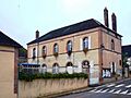
The town hall of Villiers-sur-Tholon.
-
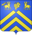
The coat of arms for Villiers-sur-Tholon.
See also
 In Spanish: Villiers-sur-Tholon para niños
