Vine Brook facts for kids
Quick facts for kids Vine Brook |
|
|---|---|
| Country | United States |
| State | Massachusetts |
| District | Middlesex County |
| Cities | Lexington, Burlington, Bedford |
| Physical characteristics | |
| Main source | Spring near the "Old Reservoir" Old Reservoir Park, Marrett Road, Lexington |
| River mouth | Shawsheen River Bedford |
| Basin features | |
| Tributaries |
|
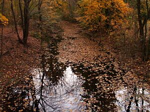
Vine Brook is a small stream located in Middlesex County, Massachusetts, in the United States. It's an important stream that flows into the Shawsheen River. For hundreds of years, from the 1600s to the 1800s, Vine Brook was a great source of power for mills.
The brook starts from a spring near the "Old Reservoir" in Lexington. It then flows north through Lexington Centre. Along its journey, it meets other smaller streams. It even goes under big places like the Middlesex Mall and Burlington Mall through a hidden tunnel called a culvert.
Vine Brook continues its path, eventually crossing into Burlington and then Bedford. Finally, it empties into the Shawsheen River. The Shawsheen River then flows into the Merrimack River, which eventually reaches the Atlantic Ocean.
This brook is well-known in Lexington and Burlington. Many old mills used its water power, connecting it deeply to the history of these towns. You'll find that many local streets and neighborhoods are named after Vine Brook. Parts of the brook also flow through parks and conservation lands in all three towns it passes through.
Contents
Vine Brook's Smaller Streams
Vine Brook has two main streams that flow into it. These are called tributaries.
- Upper Vine Brook: This stream starts in the wet areas near Marrett Road in Lexington. Some people today mistakenly think this is the main part of Vine Brook.
- Long Meadow Brook: This stream begins between Indian Hill Road and Arlington Road in Burlington.
Vine Brook's Side Channels
Vine Brook also has one important side channel that breaks off from its main path.
- Sandy Brook: After Vine Brook flows past the Burlington Mall, a part of it splits off to create Sandy Brook.
A Look at Vine Brook's Past
Before European settlers arrived around the 1630s, Native American tribes like the Nipmuck Indians traveled through the Vine Brook area. They didn't build permanent homes right by Vine Brook in Lexington because the water supply wasn't big enough for a whole tribe. However, they did have settlements closer to the larger Shawsheen River. Even though Vine Brook was small back then, it had fish!
The first European settlement in Lexington, around 1642, was built close to Vine Brook.
For centuries, from the 1600s to the 1800s, people used the brook a lot for mills. You can read more about these mills in the next section.
In the early 1900s, as Lexington was still a farming community, the brook's main use changed. Farmers used its water to irrigate their crops. In the 1930s, during a time when the government created jobs (called the WPA project), Vine Brook was made wider and deeper in some areas of Lexington. This helped farmers use it better for irrigation. Today, many parts of the brook are slowly returning to their natural, shallower size. Also, some sections of the brook were put into culverts, which are like underground tunnels.
Today, large parts of Vine Brook are protected as town-owned conservation land. While some areas of the brook have changed over time, other spots still look much like they did hundreds of years ago.
Mills Powered by Vine Brook

Many mills have operated along Vine Brook over the centuries. This industry made the brook very important to the towns it flows through. When Bedford was becoming its own town, there were discussions about which town would get the rights to the Vine Brook area because its water power was so valuable.
Here are some of the known mills, listed in order as you would go downstream:
- Muzzey Mill: The exact date is unknown, but it was located near where 1666 Mass. Ave. is today in Lexington.
- Estabrook Mill: Also an unknown date, this mill was behind where 1625 Mass. Ave. is now in Lexington. The pond created by this mill was later used for baptisms by a local church.
- Wyman Fulling Mill: This mill was built before 1794. It was located at Butterfield's Pond and North Street in Lexington.
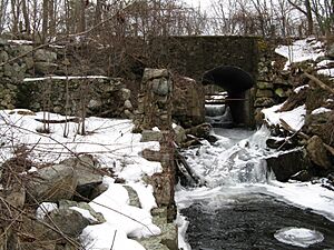
- Gibbs Mill: This mill was built on the same spot as the Wyman fulling mill. It burned down in the 1840s, but you can still see its foundations today.
- Locke Grist Mill: Built before 1794, this mill was at Butterfield's Pond and Lowell Street, just over the town line into Burlington.
- Reed Saw Mill: This mill was also built before 1794 and was still working in the 1890s. It was located off Middlesex Turnpike in Burlington.
- Vine Brook Mill: The first mill here, called the Bacon mill, was built around 1645 but was burned by Native Americans during King Philip's War. Then, the Wilson corn mill was built in 1685. Later, around 1840, a paper mill was built on the same site. This paper mill made rough paper and employed many people. When it burned down around 1850-1860, about one-tenth of the town's residents moved away. The pond created by this mill can still be seen today. Its foundations are visible off Burlington Road in Bedford.
- Other Saw Mills: Historical records mention other sawmills on both the Shawsheen River and Vine Brook. These mills created ponds that were used for cutting ice. Ice was also cut from Butterfield's Pond near Wyman's Mill.
Protecting Vine Brook's Land
Many parts of Vine Brook are now protected as conservation land by the towns they flow through. This water is very important for the local wildlife. For example, the old millpond where Vine Brook meets Route 3 in Bedford is a key spot for animals. It helps create a wildlife corridor, supporting many different kinds of animals.
Here are some of the conservation areas that include parts of Vine Brook:
- Lexington: There are two main conservation areas here. The Lower Vine Brook area is about 100 acres (0.40 km2) and has a paved bike path along the brook. The Upper Vine Brook area is about 50 acres (0.20 km2) and includes parts of Upper Vine Brook, one of the main streams that flows into Vine Brook.
- Burlington: A section of Vine Brook near where Sandy Brook splits off is a 22-acre conservation park. Further upstream on Sandy Brook, there's another 5-acre park. There's also a 3.78-acre park off Chadwick Road that touches Sandy Brook. Parts of Long Meadow Brook, another stream flowing into Vine Brook, are also conservation land. Plus, the "Muller Road Conservation Land" (over 3 acres) is right behind Vine Pond, which is connected to Vine Brook.
- Bedford: A large part of the Shawsheen River, not far from where Vine Brook joins it, is town-owned conservation land. You can even use small boats on the Shawsheen River in this area.
What's in a Name?
The first time land in what is now Lexington was mentioned in a deed was in 1636. It talked about 600 acres of land near "Vynebrooke."
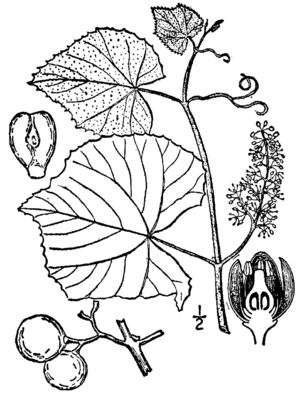
Vine Brook likely got its name because of the many grape vines that grew along its banks. Writers from the 1600s, like John Josselyn, often wrote about how common grape vines were in wet, low areas of New England.
The type of grape that probably grew by Vine Brook was called Vitis labrusca, or "Fox Grape." These writers noted how big these grapes could get (sometimes almost four inches around!) and how sweet they tasted. Even today, you can still find a few grape vines growing along the brook's banks in Lexington's conservation areas.
It's very likely that Native Americans had an ancient name for this brook, but that name is not known today. A rough translation of "Vine Brook" into the Natick Algonquin language (spoken by some Native American tribes) would be "Wenonis Seep," which means "grapevine river."
When Vine Brook Floods
In the old days, Vine Brook would often flood Waltham Street in Lexington. People living in the southwest part of town would complain that they couldn't get to church because of the flooding.
The only major flood in recent years happened on March 14 and 15, 2010. North Street in Lexington was almost completely underwater. The swelling of Vine Brook also caused major flooding in the Shawsheen River.
 | Delilah Pierce |
 | Gordon Parks |
 | Augusta Savage |
 | Charles Ethan Porter |


