
Volcán Siete Orejas facts for kids
Quick facts for kids Volcán Siete Orejas |
|
|---|---|

Relief map of Volcán Siete Orejas with Volcán Santa Maria to the SE. (Unit of scale bar is 1 km per section)
|
|
| Highest point | |
| Elevation | 3,370 m (11,060 ft) |
| Geography | |

Volcán Siete Orejas
Location in Guatemala
|
|
| Location | Quetzaltenango, Concepción Chiquirichapa, Guatemala |
| Geology | |
| Mountain type | Stratovolcano |
| Last eruption | Unknown |
Volcán Siete Orejas is a large volcano in Guatemala. Its name means "Seven Ears" in the Mam language, which is Wuq Xinkan. This volcano is a type called a stratovolcano, which means it's tall and cone-shaped, built up by many layers of hardened lava and ash.
You can find Volcán Siete Orejas in the Quetzaltenango Department. It stretches across several towns, including Quetzaltenango, Concepción Chiquirichapa, La Esperanza, and San Martin Sacatepequez. It is part of the Sierra Madre de Chiapas mountain range.
Contents
What Does Volcán Siete Orejas Look Like?
This volcano is special because it has seven main peaks! These peaks are arranged around a big crater. The southern part of this crater looks like it has fallen away.
The highest points of the volcano are on its northwest side. One peak reaches about 3,370 meters (11,056 feet) high. Another is about 3,157 meters (10,358 feet) tall.
How Does the Volcano Affect the Climate?
The volcano has a U-shape that opens towards the coast. This shape creates different weather zones. You can find both cold and warm areas close to each other on the volcano.
Inside the volcano's structure, there are hot springs. These are places where warm water comes up from underground. The volcano is also where the rio Ocosito begins. This river flows all the way to the Pacific Ocean.
Why is Volcán Siete Orejas Important for Nature?
Volcán Siete Orejas is a very important place for nature. It is part of the Sierra Madre de Chiapas mountain range, which is home to many unique plants and animals.
What Special Plants Live Here?
One special tree found here is the endangered Guatemalan Fir. This tree is also known as "Pinabete." It is very important to protect it.
What Animals Can You Find?
The volcano is part of a large area where animals can move freely. This area is called a biological corridor. Many bird species live here, including:
- the pink-headed warbler
- the black-capped siskin
- the highland guan
- the rufous-collared robin
- the white-breasted hawk
- the rufous-browed wren
What is the Cultural Importance of the Volcano?
The ridgeline, or top edge, of Volcán Siete Orejas has more than 18 special altars. These altars are used for Mayan ceremonies. Many local Mayan priests still use them today.
The name "Siete Orejas" comes from the local Mam language name, Wuq Xinkan. Local people say this name comes from an old story about a large rock on one of the peaks.
What Fun Activities Can You Do at Volcán Siete Orejas?
On clear days, the top of the volcano offers amazing views. You can see the city of Quetzaltenango. You can also see other volcanoes like Santa Maria, Santiaguito, Tajumulco, and Tacana.
In 2009, the town of Concepción Chiquirichapa created a special place called the Regional Ecological Park "Cacique Dormido." This park offers many fun activities on the volcano, such as:
- Hiking
- Camping
- Bird-watching
- Cultural tours
Gallery
- Siete Orejas Volcano
-
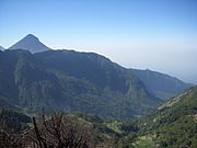
Looking from the ridgeline down into the old volcanic edifice, with the peak of Volcan Santa Maria in the background.
-
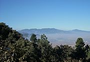
Volcán Siete Orejas as seen from the NE.
-
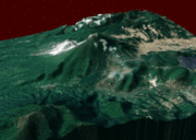
Animated 3D view of the Siete Orejas and Santa María volcanoes (click to see animation).


See also
 In Spanish: Volcán Siete Orejas para niños
- List of volcanoes in Guatemala
