Waikōwhai facts for kids
Quick facts for kids
Waikōwhai
|
|
|---|---|
|
Suburb
|
|

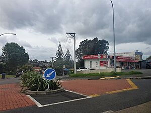
Waikowhai Superette on Hillsborough Road
|
|
| Country | New Zealand |
| Local authority | Auckland |
| Electoral ward | Albert-Eden-Puketāpapa ward |
| Local board | Puketāpapa Local Board |
| Area | |
| • Land | 136 ha (336 acre) |
| Population
(June 2023)
|
|
| • Total | 2,150 |
|
|
||
Waikōwhai is a suburb in Auckland, New Zealand. It is managed by the Auckland Council. Waikōwhai is special because it has the largest area of native forest left on the Auckland isthmus.
This forest was not cleared for farming because its soil was not very fertile. Instead, it was given to the Wesley Mission. Today, this forest is a valuable home for many of Auckland's original plants and animals. The Waikōwhai Walkway is a 10 km (6.2 mi) path that connects Onehunga to Lynfield Cove.
Contents
What's in a Name?
The name Waikōwhai (sometimes spelled Waikowai) appeared on old European maps and in newspapers from the 1850s. Its exact meaning in the Māori language is not fully clear. It might mean "kōwhai tree waters" or "yellow water."
A Look Back: Waikōwhai's History
Early Māori Settlement
People from the Tāmaki Māori tribes have lived in the southern Auckland isthmus since at least the 1200s. There was an old trail in Waikōwhai. This trail connected Te Tōanga Waka (a place where canoes were carried over land) in the west to Onehunga in the east.
The iwi (tribes) and hapū (sub-tribes) living around the Manukau Harbour would move with the seasons. They gathered food and farmed in different areas. By the early 1700s, Waikōwhai was part of the rohe (territory) of the Waiohua tribe.
After the Waiohua chief, Kiwi Tāmaki, was defeated, the area became part of the Ngāti Whātua territory. Today, this is known as Ngāti Whātua Ōrākei.
Important Historical Sites
Two important historical places are known in the Waikōwhai area. These were marked on an 1853 map of the Manukau Harbour.
- Cape Horn headland: This was the site of a fortified pā (Māori village or fort) called Matengarahi.
- Wattle Bay area: Many shell middens (piles of shells left by people eating seafood) have been found here. This site was called Taunahi.
European Settlement and Development
The land in Waikōwhai was bought on March 26, 1844. Most of the Waikōwhai suburb today was given to the Wesleyan Methodist Church by the Crown in 1850. The church used this land for its mission, and students would go there for fishing and swimming.
In the early 1900s, Waikōwhai Bay was a popular spot. People from Auckland would visit for swimming, day trips, and picnics. However, by the 1930s, the bay became less popular. This was because of increasing pollution in the Manukau Harbour.
In 1927, the Wesley Trust started to develop the land in Waikōwhai. They divided it into smaller sections for houses. The government also started building houses there from the 1940s onwards.
During the 1950s and 1960s, a rubbish tip and landfill were built at Waikōwhai Park. This caused problems for the area. It led to pollution and made it harder for people to get to Waikōwhai Bay.
Waikōwhai's Population
Waikōwhai covers about 1.36 km2 (0.53 sq mi). As of June 2023, it had an estimated population of 2,150. This means there are about 1581 people living in each square kilometer.
The population of Waikōwhai has grown over the years:
- 2006: 4,833 people
- 2013: 4,956 people
- 2018: 5,439 people
In 2018, there were 1,518 households in Waikōwhai. About 20% of the people were under 15 years old. Many people in Waikōwhai were born overseas, about 52% of the population.
Places to See and Things to Do
- The Arkell Homestead: This is a historic country house at 461 Hillsborough Road. It used to be a home for the Sisters of the Good Shepherd. Now, it is part of the Metlifecare Retirement Village.
- Waikōwhai Park: This is a large park next to the Manukau Harbour. The Wesleyan Mission Trust gave the land for the park in 1909. It opened in February 1914 and was a popular place for swimming, camping, and picnics. The park is mostly covered by kohekohe forest.
- The Waikōwhai Walkway: This is a 10 km (6.2 mi) path. It connects Onehunga to Lynfield Cove, offering great views.
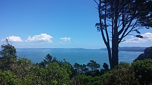
- Manukau Harbour Coast: This area includes places like Cape Horn, Waikōwhai Bay, Faulkner Bay, and Wesley Bay. Cape Horn has a lookout point where you can see across the Manukau Harbour.
Schools in Waikōwhai
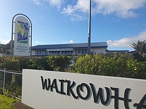
- Waikowhai Intermediate School: This school is for students in years 7 and 8 (around ages 11-13). It opened in 1964. It was once used as a campus for a teacher training college.
- Waikowhai School: This is a primary school for students in years 1 to 6 (around ages 5-10). It opened in 1956.
Both schools welcome both boys and girls.
Students in Waikōwhai can also attend nearby secondary schools like Lynfield College and Mount Roskill Grammar School. For Catholic secondary education, students can go to Marcellin College or St Peter's College.
 | May Edward Chinn |
 | Rebecca Cole |
 | Alexa Canady |
 | Dorothy Lavinia Brown |


