
Waimangaroa facts for kids
Quick facts for kids
Waimangaroa
|
|
|---|---|

Denniston Road Scenic Reserve
|
|
| Country | New Zealand |
| Region | West Coast |
| District | Buller District |
| Ward | Seddon |
| Electorates |
|
| Area | |
| • Total | 1.58 km2 (0.61 sq mi) |
| Population
(June 2023)
|
|
| • Total | 220 |
| • Density | 139/km2 (361/sq mi) |
Waimangaroa is a small town located on the West Coast of New Zealand. It's a place with a rich history, especially linked to coal mining. The town sits on the southwest bank of the Waimangaroa River, at the bottom of the Denniston Plateau.
Waimangaroa is about 17 kilometers (10.5 miles) northeast of Westport. It is also 13 kilometers southeast of Granity. The old coal town of Denniston is only about 5 kilometers (3 miles) to the southeast.
Contents
Exploring Waimangaroa's Surroundings
The area around Waimangaroa is full of interesting places. You can find the Bridle Track here, which is a beautiful bush path. It leads southeast along the Denniston Incline into the hills of the Mt William Range, heading towards Denniston.
Coal Mining in the Area
Coal mining has been very important to Waimangaroa. The Stockton mine is a large open-pit coal mine nearby. It is operated by a company called Solid Energy.
Beaches and Water Safety
The beaches to the west of Waimangaroa have strong and dangerous currents. Because of this, they are not safe places for swimming. It's important to be careful near the water.
Waimangaroa's Railway History
The Ngakawau Branch railway line runs right through Waimangaroa. This railway is a special kind of line called a branch line.
Early Days of the Railway
The railway first opened in Waimangaroa on August 5, 1876. It used to go all the way to Seddonville, but now it stops in Ngakawau.
The Conns Creek Branch
From 1877 until 1967, Waimangaroa was also a junction for another railway line. This was the Conns Creek Branch, which went east along the Waimangaroa River. It reached the bottom of the Denniston Incline.
Passenger Services and Coal Transport
Passenger trains stopped running on the Conns Creek Branch in 1931. On the Ngakawau Branch, passenger services ended on October 14, 1946. Since then, the railway through Waimangaroa has mostly been used to carry coal.
People and Population
Waimangaroa is considered a rural settlement by Statistics New Zealand. It covers an area of 1.58 square kilometers.
How Many People Live Here?
In 2018, Waimangaroa had a population of 228 people. This was a small decrease from 2013, but a slight increase from 2006. There were 99 households in the town.
Age Groups in Waimangaroa
- About 19.7% of the people were under 15 years old.
- Around 9.2% were between 15 and 29 years old.
- Most people, about 46.1%, were aged 30 to 64.
- About 23.7% of the population was 65 years or older.
Ethnic Backgrounds
Most people in Waimangaroa, about 89.5%, are European or Pākehā. About 10.5% are Māori, and smaller numbers are Pasifika or other ethnic groups.
Education in Waimangaroa
Waimangaroa School used to be a school for children from years 1 to 8. The school celebrated its 125th anniversary in 2004. However, it closed permanently in 2012. The building is now privately owned. Children from Waimangaroa now go to schools in Westport.
Notable People from Waimangaroa
- Becky Manawatu (born 1982), a well-known writer, is from Waimangaroa.
Images for kids
-
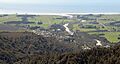
Waimangaroa viewed from the Denniston road

