Waldron, Arkansas facts for kids
Quick facts for kids
Waldron, Arkansas
|
|
|---|---|
|
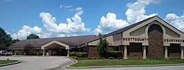
Clockwise from top: Scott County Courthouse, Downtown Waldron, and the Old Scott County Courthouse
|
|

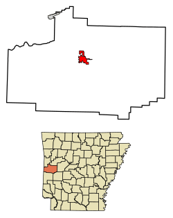
Location of Waldron in Scott County, Arkansas.
|
|
| Country | United States |
| State | Arkansas |
| County | Scott |
| Founded by | W. G. Featherston |
| Named for | W. P. Waldron |
| Area | |
| • Total | 5.72 sq mi (14.83 km2) |
| • Land | 5.63 sq mi (14.59 km2) |
| • Water | 0.09 sq mi (0.23 km2) |
| Elevation | 646 ft (197 m) |
| Population
(2020)
|
|
| • Total | 3,386 |
| • Density | 600.99/sq mi (232.03/km2) |
| Time zone | UTC-6 (Central (CST)) |
| • Summer (DST) | UTC-5 (CDT) |
| ZIP codes |
72924, 72958
|
| Area code(s) | 479 |
| FIPS code | 05-72380 |
| GNIS feature ID | 2405661 |
Waldron is a city located in Scott County, Arkansas, in the United States. It's the main town, or county seat, of Scott County. In 2020, about 3,386 people lived there.
Contents
History of Waldron
Waldron was first planned out in 1845 by a surveyor named W. P. Waldron. The city was named after him. A post office opened in Waldron in 1846, helping the community grow.
The city officially became a town in 1875. In 1901, the Arkansas Western Railroad reached Waldron. This connected the city to Heavener, Oklahoma, making it easier for people and goods to travel. Today, this railway line is used by the Arkansas Southern Railroad.
Geography and Location
Waldron covers a total area of about 14.83 square kilometers (5.72 square miles). Most of this area is land, with a small part being water. The city is located about 38 miles south of Fort Smith. It is also close to the Poteau River.
Climate in Waldron
The weather in Waldron is known for its hot and humid summers. Winters are usually mild to cool. This type of weather is called a humid subtropical climate. On climate maps, you might see it labeled as "Cfa".
| Climate data for Waldron, Arkansas (1991–2020 normals, extremes 1919–present) | |||||||||||||
|---|---|---|---|---|---|---|---|---|---|---|---|---|---|
| Month | Jan | Feb | Mar | Apr | May | Jun | Jul | Aug | Sep | Oct | Nov | Dec | Year |
| Record high °F (°C) | 84 (29) |
90 (32) |
95 (35) |
94 (34) |
99 (37) |
110 (43) |
111 (44) |
113 (45) |
114 (46) |
103 (39) |
87 (31) |
82 (28) |
114 (46) |
| Mean maximum °F (°C) | 71.8 (22.1) |
75.2 (24.0) |
81.4 (27.4) |
85.9 (29.9) |
89.9 (32.2) |
94.2 (34.6) |
99.5 (37.5) |
99.5 (37.5) |
95.2 (35.1) |
87.8 (31.0) |
77.8 (25.4) |
71.7 (22.1) |
101.5 (38.6) |
| Mean daily maximum °F (°C) | 50.6 (10.3) |
55.6 (13.1) |
64.0 (17.8) |
72.4 (22.4) |
79.1 (26.2) |
87.3 (30.7) |
92.2 (33.4) |
92.0 (33.3) |
85.0 (29.4) |
73.8 (23.2) |
61.6 (16.4) |
53.0 (11.7) |
72.2 (22.3) |
| Daily mean °F (°C) | 39.1 (3.9) |
43.4 (6.3) |
51.3 (10.7) |
59.7 (15.4) |
67.8 (19.9) |
75.9 (24.4) |
80.3 (26.8) |
79.5 (26.4) |
72.2 (22.3) |
61.0 (16.1) |
49.6 (9.8) |
41.6 (5.3) |
60.1 (15.6) |
| Mean daily minimum °F (°C) | 27.7 (−2.4) |
31.2 (−0.4) |
38.7 (3.7) |
46.9 (8.3) |
56.4 (13.6) |
64.5 (18.1) |
68.4 (20.2) |
66.9 (19.4) |
59.5 (15.3) |
48.3 (9.1) |
37.7 (3.2) |
30.3 (−0.9) |
48.0 (8.9) |
| Mean minimum °F (°C) | 11.1 (−11.6) |
15.2 (−9.3) |
20.6 (−6.3) |
29.8 (−1.2) |
40.3 (4.6) |
54.0 (12.2) |
59.6 (15.3) |
57.3 (14.1) |
43.4 (6.3) |
30.5 (−0.8) |
20.5 (−6.4) |
15.4 (−9.2) |
8.1 (−13.3) |
| Record low °F (°C) | −14 (−26) |
−20 (−29) |
4 (−16) |
19 (−7) |
31 (−1) |
44 (7) |
49 (9) |
46 (8) |
30 (−1) |
20 (−7) |
6 (−14) |
−7 (−22) |
−20 (−29) |
| Average precipitation inches (mm) | 3.43 (87) |
3.17 (81) |
4.63 (118) |
5.35 (136) |
5.95 (151) |
4.67 (119) |
3.89 (99) |
3.74 (95) |
4.21 (107) |
4.66 (118) |
4.93 (125) |
4.59 (117) |
53.22 (1,352) |
| Average snowfall inches (cm) | 1.1 (2.8) |
1.0 (2.5) |
0.7 (1.8) |
0.0 (0.0) |
0.0 (0.0) |
0.0 (0.0) |
0.0 (0.0) |
0.0 (0.0) |
0.0 (0.0) |
0.0 (0.0) |
0.0 (0.0) |
0.1 (0.25) |
2.9 (7.4) |
| Average precipitation days (≥ 0.01 in) | 7.0 | 7.6 | 9.2 | 8.6 | 9.8 | 8.0 | 7.7 | 6.9 | 6.8 | 7.4 | 7.3 | 8.2 | 94.5 |
| Average snowy days (≥ 0.1 in) | 0.6 | 0.6 | 0.2 | 0.0 | 0.0 | 0.0 | 0.0 | 0.0 | 0.0 | 0.0 | 0.0 | 0.2 | 1.6 |
| Source: NOAA | |||||||||||||
Population and People
The number of people living in Waldron has changed over the years. Here's how the population has grown:
| Historical population | |||
|---|---|---|---|
| Census | Pop. | %± | |
| 1850 | 90 | — | |
| 1870 | 162 | — | |
| 1880 | 289 | 78.4% | |
| 1890 | 487 | 68.5% | |
| 1900 | 487 | 0.0% | |
| 1910 | 900 | 84.8% | |
| 1920 | 918 | 2.0% | |
| 1930 | 1,077 | 17.3% | |
| 1940 | 1,298 | 20.5% | |
| 1950 | 1,292 | −0.5% | |
| 1960 | 1,619 | 25.3% | |
| 1970 | 2,132 | 31.7% | |
| 1980 | 2,642 | 23.9% | |
| 1990 | 3,024 | 14.5% | |
| 2000 | 3,508 | 16.0% | |
| 2010 | 3,618 | 3.1% | |
| 2020 | 3,386 | −6.4% | |
| U.S. Decennial Census | |||
Waldron's Population in 2020
The 2020 United States census counted 3,386 people living in Waldron. These people lived in 1,328 households, with 854 of them being families.
Here's a look at the different groups of people living in Waldron in 2020:
| Race | Number | Percentage |
|---|---|---|
| White (non-Hispanic) | 2,574 | 76.02% |
| Black or African American (non-Hispanic) | 10 | 0.3% |
| Native American | 38 | 1.12% |
| Asian | 82 | 2.42% |
| Pacific Islander | 1 | 0.03% |
| Other/Mixed | 154 | 4.55% |
| Hispanic or Latino | 527 | 15.56% |
Education in Waldron
Students in Waldron attend public schools run by the Waldron School District. After elementary and middle school, students go on to graduate from Waldron High School. The school's mascot is the Bulldog, and their colors are orange and black.
Famous People from Waldron
Many interesting people have come from Waldron, Arkansas. Some of them include:
- Evelyn Ammons – She was a member of the Arkansas House of Representatives.
- Doak S. Campbell – He was the person who started Florida State University.
- Gary Darnell – A well-known coach for college football teams.
- James Farley – An actor who appeared in silent films.
- Ashley McBryde – A popular country music singer and songwriter.
- Terry Rice – Another member of the Arkansas House of Representatives.
See also
 In Spanish: Waldron (Arkansas) para niños
 | William Lucy |
 | Charles Hayes |
 | Cleveland Robinson |


