Walling, Tennessee facts for kids
Quick facts for kids
Walling, Tennessee
|
|
|---|---|

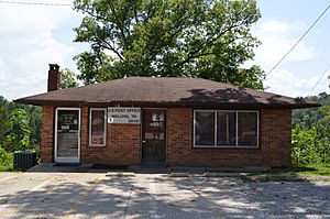
Post office in Walling
|
|
| Country | United States |
| State | Tennessee |
| County | White |
| Elevation | 892 ft (272 m) |
| Time zone | UTC-6 (Central (CST)) |
| • Summer (DST) | UTC-5 (CDT) |
| ZIP code |
38587
|
| Area code(s) | 931 |
| GNIS feature ID | 1304347 |
Walling is a small place in White County, Tennessee, United States. It's known as an unincorporated community. This means it's a group of homes and businesses that isn't officially a city or town with its own local government. Instead, it's part of the larger county.
Contents
Discovering Walling, Tennessee
Walling is located in the beautiful state of Tennessee. It's a quiet spot that offers a glimpse into rural life. Even though it's not a big city, it's an important part of the local area.
Where is Walling Located?
You can find Walling along the Caney Fork river. This river is a well-known natural feature in Tennessee. Walling is situated southwest of a place called Doyle and east of the popular Rock Island State Park. This park is famous for its waterfalls and outdoor activities.
Getting Around Walling
A main road, Tennessee State Route 136, goes right through the community. This road helps people travel to and from Walling, connecting it to other towns and areas in Tennessee. It's an important route for residents and visitors.
Services in Walling
Even as an unincorporated community, Walling has its own post office. This means people living there can send and receive mail easily. The post office uses the ZIP code 38587, which helps sort mail for everyone in the area.
The Story Behind the Name
Have you ever wondered how places get their names? For Walling, it's believed that the community was named after an early family who settled there. Many places in the United States are named after the first families who helped build and grow the area.
 | Delilah Pierce |
 | Gordon Parks |
 | Augusta Savage |
 | Charles Ethan Porter |


