Walnut Springs Park facts for kids
Quick facts for kids Walnut Springs Park |
|
|---|---|
 |
|
| Country | United States |
| State | Texas |
| Physical characteristics | |
| Main source | Seguin, Texas 164 m (538 ft) 29°34′05″N 97°58′06″W / 29.56806°N 97.96833°W |
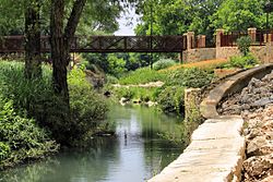
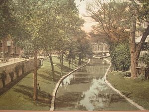
Walnut Springs Park is a beautiful green space in Seguin, Texas. It is also known as the Walnut Branch Walk. The park has many paths and bridges that follow the Walnut Branch. This is a small stream that flows into the Guadalupe River. The stream gets its water from several small springs.
The park is a special part of the city. It is important for both nature and history.
Contents
Park History: How It Began
The town of Seguin started in 1838. It was just a few blocks from the springs. Many of the first and best homes were built along Walnut Branch. The stream gave clean water for people and animals. It was used for laundry and cleaning. Sebastopol House State Historic Site is one of these old homes. It was built before the Civil War.
Designing the Park
In the late 1920s, people started planning for a park. Seguin's Mayor Max Starcke helped with this idea. Robert Hugman, an architect from San Antonio, shared his plans. These plans would create Walnut Springs Park.
Building During Hard Times
Money became available in 1933 to make the stream into a park. This money came from federal programs. These programs helped people find work during the Great Depression. Robert Hugman designed the park. He also designed the famous San Antonio River Walk. That project was finished in 1941. Hugman also designed Max Starcke Park in Seguin. This larger park is along the Guadalupe River. Many ideas used in the River Walk were first tried at Walnut Branch.
Building with the Civilian Conservation Corps
In June 1933, workers from the Civilian Conservation Corps started building. They built paths and bridges along Walnut Branch. They also lined the stream banks with stone walls. Small dams, low waterfalls, and quiet pools were built. These followed the natural path of the stream. It runs along the edge of downtown Seguin. An old stagecoach route was also marked with stone walls.
The park used the natural beauty of the area. It had native trees, ferns, and other plants. The park is much lower than the downtown streets. The flowing stream and shade create a cool, humid area. This is like its own special microclimate.
Park Challenges: Neglect and Decay
The park was not cared for during a bad drought in the 1950s. Even so, the main spring never dried up. People worried that mosquitoes in the ponds could spread diseases. One fear was polio. Because of this, the stepping stone dams were removed.
City leaders lost interest in keeping the park nice. It became overgrown with weeds. This made it a place for snakes and pests. The water flow was limited. The beautiful waterfalls and pools were gone. The park was almost forgotten for many years. Much of the land was still privately owned. As land became more valuable, some owners built on what was once parkland.
To make things worse, the United States Army Corps of Engineers changed the stream. They straightened parts of it upstream. This made floodwater flow faster into the lower section.
Park Rebirth: Revitalization
In the 1980s, people started having new ideas. They wanted to bring the park back to life. The Women's Federated Clubs and the Seguin Garden Club started planting. They planted roses along the old stagecoach route. This area became known as the Memorial Rose Garden. Every spring, the community holds a "Moonlight and Roses Festival" there.
A New Plan for the Park
In 1995, the city made a plan to fix up the park. By 2002, voters agreed to start the project. But there were delays in getting money. Major work did not begin until 2006. Voters approved funds to buy important land for the park. State and federal officials were asked for help with funding.
The Army Corps of Engineers created the main design plan. They wanted to fix the earlier damage. The Corps now believed in using natural plants and wetlands. These help soak up water and slow down floods. They also wanted the stream to curve naturally.
On May 14, 2011, the main part of the park was finished. The city celebrated the park's new beginning. Plaques were placed on the pedestrian bridge. They honor the people who made the project possible.
Park Growth: Expansion Plans
There are plans to make the park even bigger. The park walk is called the Walnut Branch Linear Park Trail. It will go further north to Highway 78. It will also go a few blocks south to Convent Street. Eventually, it might even connect to Max Starcke Park.
A Special Place: Lone Star Legacy Park
In 2012, Walnut Springs Park received a special award. The Texas Recreation and Park Society gave it the "Lone Star Legacy Park" award. This means the park is a very important and historic place in Texas.
 | Jackie Robinson |
 | Jack Johnson |
 | Althea Gibson |
 | Arthur Ashe |
 | Muhammad Ali |


