Walsh Bay facts for kids
Quick facts for kids Walsh Bay |
|
|---|---|

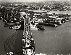
A 1937 image of the Sydney Harbour Bridge with Walsh Bay to the right of the Bridge in the centre of the image
|
|
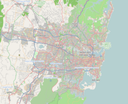
| Location | Sydney, New South Wales |
| Coordinates | 33°51′16″S 151°12′16″E / 33.8545°S 151.2045°E |
| Etymology | Henry Deane Walsh |
| Part of | Sydney Harbour |
Walsh Bay is a small bay located within Sydney Harbour in Sydney, New South Wales. It's about 1,000 meters south of the suburb McMahons Point. The bay is named after Henry Deane Walsh, who was a chief engineer for the Sydney Harbour Trust.
Walsh Bay stretches from Dawes Point in the northeast to Millers Point in the southwest. The original shoreline has changed over time. It now includes areas known as Piers 1 to 9.
Today, Walsh Bay is often called the Walsh Bay Wharves Precinct or the Walsh Bay Arts Precinct. This is a special area by the harbour. It used to be a busy working port, where ships loaded and unloaded goods. Now, the old wharves have been turned into modern apartments, theatres, restaurants, cafes, and even a hotel. In 2015, it became a major arts area. Many parts of this precinct are protected as heritage sites.
History of Walsh Bay
The area around Walsh Bay has a rich history. It was first known by the Aboriginal names Tar-ra and Tullagalla.
How Walsh Bay Got Its Name
The bay was officially named Walsh Bay in 1918. This happened when plans were drawn up for a big new 'wharfage scheme'. This plan aimed to update all of Sydney's docks. The goal was to make them ready for modern steamships and motor vehicles.
This big update was planned by Henry Deane Walsh, the chief engineer. The chairman of the Sydney Harbour Trust at the time was Robert Rowan Purdon Hickson. A new road built around this area, Hickson Road, was named after him.
Building the Wharves
The wharves at Walsh Bay were built between 1912 and 1921. These structures were very important for Sydney's growth. They helped the city handle more trade and goods coming in by sea.
 | Delilah Pierce |
 | Gordon Parks |
 | Augusta Savage |
 | Charles Ethan Porter |


