
Walterhill, Tennessee facts for kids
Quick facts for kids
Walterhill, Tennessee
|
|
|---|---|

Location of Walterhill, Tennessee
|
|
| Country | United States |
| State | Tennessee |
| County | Rutherford |
| Area | |
| • Total | 3.01 sq mi (7.79 km2) |
| • Land | 3.01 sq mi (7.79 km2) |
| • Water | 0.00 sq mi (0.00 km2) |
| Elevation | 545 ft (166 m) |
| Population
(2020)
|
|
| • Total | 407 |
| • Density | 135.40/sq mi (52.28/km2) |
| Time zone | UTC-6 (Central (CST)) |
| • Summer (DST) | UTC-5 (CDT) |
| FIPS code | 47-77980 |
| GNIS feature ID | 1304364 |
Walterhill, also called Walter Hill, is a small community in Rutherford County, Tennessee. It is known as a census-designated place (CDP). This means it is an area that the U.S. Census Bureau defines for gathering population data. It is not an officially incorporated town. In 2020, about 407 people lived there.
Walterhill is home to the Walterhill Floodplain State Natural Area. This special natural area is about 34 acres (14 hectares) big. It was created to protect a very rare plant called the Stones River bladderpod. This plant grows only in the Stones River floodplain. A floodplain is a flat area of land next to a river that might get flooded. Walterhill is also known locally for having the Middle Point landfill. A landfill is a place where trash is buried.
Geography of Walterhill

Walterhill is located at specific geographic coordinates: 35.970674 degrees North and -86.385838 degrees West. These numbers help pinpoint its exact spot on a map.
The United States Census Bureau collects information about places in the U.S. They say that Walterhill covers a total area of about 3.0 square miles (7.77 square kilometers). All of this area is land, meaning there are no large lakes or rivers within its official boundaries.
Walterhill's Population and People
| Historical population | |||
|---|---|---|---|
| Census | Pop. | %± | |
| 2020 | 407 | — | |
| U.S. Decennial Census | |||
The population of Walterhill has changed over time. In the year 2000, there were 1,523 people living in the area. These people lived in 525 households, and 431 of these were families. The population density was about 262 people per square mile (101 people per square kilometer).
Most people in Walterhill in 2000 were White (about 91.46%). There were also African American people (6.63%), Native American people (0.20%), and Asian people (0.26%). A small number of people were from other racial backgrounds or were of Hispanic or Latino origin.
In 2000, many households in Walterhill had children. About 43.4% of households had kids under 18 living with them. Most families (68.8%) were married couples living together. The average household had about 2.90 people, and the average family had about 3.23 people.
The age of the people in Walterhill in 2000 was spread out. About 28.8% of the population was under 18 years old. About 7.5% were 65 years old or older. The average age was 36 years. For every 100 females, there were about 101.7 males.
The median income for a household in Walterhill in 2000 was $58,438. The median income for a family was $61,111. This means that half of the households earned more than this amount, and half earned less. The average income per person was $22,419. A small percentage of families (3.2%) and people (3.3%) lived below the poverty line.
Images for kids
-
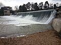
The Walter Hill dam is on the East Fork of Stones River. You can see the old hydroelectric station from the early 1900s on the left.
See also
 In Spanish: Walterhill para niños
