
Stones River facts for kids
Quick facts for kids Stones River |
|
|---|---|

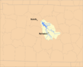
Map of the Stones River Watershed
|
|
| Country | United States |
| Physical characteristics | |
| Main source | East Fork - Short Mountain, Cannon County Middle Fork - Hoovers Gap, Rutherford County West Fork - Tennessee Valley Divide in Rutherford County East Fork - 1,120 feet (341.4 m) Middle Fork - 923 feet (281.3 m) West Fork - 792 feet (241.4 m) |
| River mouth | Cumberland River near Nashville 413 feet (125.9 m) 36°11′30″N 86°39′45″W / 36.19167°N 86.66250°W |
| Length | Main River - 32.4 miles (52.1 km) East Fork - 54.0 miles (86.9 km) Middle Fork - 19.8 miles (31.9 km) West Fork - 39.1 miles (62.9 km) |
| Basin features | |
| Basin size | 921 square miles (2,385.4 km2) |
The Stones River is an important river in the eastern part of Tennessee's Nashville Basin area. It was named after an explorer named Uriah Stone. He explored the river in 1767. Sometimes, people spell it as "Stone's River."
Contents
The Stones River: A Tennessee Treasure
.jpg)
The Stones River is made up of three main parts, called forks. These are the West Fork, the Middle Fork, and the East Fork. Each fork starts in a different place and flows for many miles before joining together.
Where Does the Stones River Flow?
The West Fork is about 39.1 miles long. It begins in the southern part of Rutherford County. This part of the river flows near Murfreesboro. The Stones River National Battlefield is located along the West Fork. This was the site of a very important battle during the American Civil War in 1862 and 1863.
The Middle Fork is about 19.8 miles long. It starts in an area with small hills near Bedford County. This area, called Hoovers Gap, was important for moving soldiers during the Civil War. The Middle Fork eventually meets the West Fork.
The East Fork is the longest, at 54.0 miles. It begins in Cannon County on Short Mountain. This mountain is part of the Cumberland Plateau. The East Fork flows through Woodbury, which is the main town in Cannon County. It also flows near the Alvin C. York Veterans Affairs hospital.
J. Percy Priest Dam and Lake
The West and East forks of the Stones River come together in northeastern Rutherford County, near Smyrna. At this meeting point, the river slows down because of the J. Percy Priest Dam. The United States Army Corps of Engineers built this dam in the 1960s. It was named after a former Congressman from Nashville.
The dam created a large lake called J. Percy Priest Lake. This lake changed how people lived in Nashville in the 1960s and 1970s. Many people wanted to live near the lake. The lake has many fun things to do, like boat ramps, marinas, parks, campgrounds, and even a beach.
In 1979, there was an incident at the dam. Some people tried to damage the dam, hoping it would cause flooding. However, they only managed to damage some doors at the base of the dam. The dam remained strong and safe.

You can see the dam from the bridge on Interstate 40. Right below the dam, there is a good spot for fishing. Also, the Stones River Greenway trail starts just below the dam. This trail is part of the larger Nashville Greenways Project, which creates paths for walking and biking.
Below the Dam: The Lower River
After flowing past Percy Priest Dam, the Stones River goes through an area called Clover Bottom. This is a large flat area that used to be a big farm. The historic Clover Bottom Mansion is located here. After being empty for many years, it is now the main office for the Tennessee Historical Commission.
Near where the Stones River flows into the Cumberland River, there is a private golf club. Today, many people think of the Stones River mostly because of Percy Priest Lake. The dam helps control floods, which is very important for preventing flooding in downtown Nashville.
Images for kids
-
Map of the Stones River Watershed
-
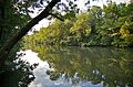
Stones River along the Murfreesboro Greenway
-
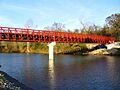
The Stone Rivers Pedestrian Greenway Bridge in Nashville
