Rutherford County, Tennessee facts for kids
Quick facts for kids
Rutherford County
|
|||
|---|---|---|---|

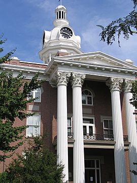
Rutherford County Courthouse, Murfreesboro
|
|||
|
|||

Location within the U.S. state of Tennessee
|
|||
 Tennessee's location within the U.S. |
|||
| Country | |||
| State | |||
| Founded | October 25, 1803 | ||
| Named for | Griffith Rutherford | ||
| Seat | Murfreesboro | ||
| Largest city | Murfreesboro | ||
| Area | |||
| • Total | 624 sq mi (1,620 km2) | ||
| • Land | 619 sq mi (1,600 km2) | ||
| • Water | 4.7 sq mi (12 km2) 0.8%% | ||
| Population
(2020)
|
|||
| • Total | 341,486 | ||
| • Estimate
(2023)
|
367,101 |
||
| • Density | 547.3/sq mi (211.30/km2) | ||
| Time zone | UTC−6 (Central) | ||
| • Summer (DST) | UTC−5 (CDT) | ||
| ZIP Codes |
37037, 37060, 37063, 37085, 37086, 37089, 37118, 37127, 37128, 37129, 37130, 37131, 37132, 37133, 37153, 37167
|
||
| Area code | 615, 629 | ||
| Congressional district | 4th | ||
Rutherford County is a county located in the state of Tennessee. It is found in the middle part of Tennessee. In 2023, about 367,101 people lived there. This makes it the fourth-most populated county in Tennessee. Experts think it might become the third largest by 2050.
The main town, or county seat, is Murfreesboro. This city is also the exact center of Tennessee. In 2010, it was the population center for the whole state. Rutherford County is part of the larger Nashville area.
Contents
History of Rutherford County
How Rutherford County Was Formed
Rutherford County was created in 1803. It was made from parts of three other counties: Davidson, Williamson, and Wilson. The county was named after Griffith Rutherford. He was a general in the American Revolutionary War. After the war, he moved to Middle Tennessee. He also served in the government of the Southwest Territory.
Rutherford County During the Civil War
Rutherford County strongly supported the Confederacy during the American Civil War. On June 8, 1861, people voted for Tennessee to leave the United States. The vote was 2,392 for leaving and only 73 against.
Because of its central spot near Nashville, Rutherford County was important in the war. One of the bloodiest battles happened here. It was called the Battle of Stones River. This battle took place from December 31, 1862, to January 2, 1863.
On July 13, 1862, Confederate General Nathan Bedford Forrest led a cavalry attack. This attack made all the Union soldiers in the area give up. But Union troops soon returned and stayed until the war ended.
Life After the Civil War

In 1884, Bradley Academy opened in Murfreesboro. It was the first high school for African American students in Rutherford County. Boys and girls could both attend this school. The Murfreesboro City Schools system ran it. Bradley Academy was added to the National Register of Historic Places in 1990.
Recent History and Growth
In the early 2000s, many Muslim families moved to the county. They settled mostly in and around Murfreesboro. They wanted to build a mosque, which is a place of worship. This project faced some challenges and legal discussions. Eventually, a federal court allowed the mosque to be built.
Geography and Nature
Rutherford County covers about 624 square miles. Most of this area, about 619 square miles, is land. The rest, about 4.7 square miles, is water.
Neighboring Counties
Rutherford County shares borders with several other counties:
- Wilson County (to the north)
- Cannon County (to the east)
- Coffee County (to the southeast)
- Bedford County (to the south)
- Marshall County (to the southwest)
- Williamson County (to the west)
- Davidson County (to the northwest)
Protected Natural Areas
The county has important natural spaces:
- Stones River National Battlefield (a national park)
It also has several state-protected areas:
- Flat Rock Cedar Glades and Barrens State Natural Area
- Gattinger's Cedar Glade and Barrens State Natural Area (part)
- Long Hunter State Park (part)
- Manus Road Cedar Glade State Natural Area
- Overbridge State Natural Area
- Percy Priest Wildlife Management Area (part)
- Elsie Quarterman Cedar Glade State Natural Area
- Fate Sanders Barrens State Natural Area
- Sunnybell Cedar Glade State Natural Area
- Stones River Cedar Glade and Barrens State Natural Area
- Walterhill Floodplain State Natural Area
People of Rutherford County
| Historical population | |||
|---|---|---|---|
| Census | Pop. | %± | |
| 1810 | 10,265 | — | |
| 1820 | 19,552 | 90.5% | |
| 1830 | 26,134 | 33.7% | |
| 1840 | 24,280 | −7.1% | |
| 1850 | 29,122 | 19.9% | |
| 1860 | 27,918 | −4.1% | |
| 1870 | 33,289 | 19.2% | |
| 1880 | 36,741 | 10.4% | |
| 1890 | 35,097 | −4.5% | |
| 1900 | 33,543 | −4.4% | |
| 1910 | 33,199 | −1.0% | |
| 1920 | 33,059 | −0.4% | |
| 1930 | 32,286 | −2.3% | |
| 1940 | 33,604 | 4.1% | |
| 1950 | 40,696 | 21.1% | |
| 1960 | 52,368 | 28.7% | |
| 1970 | 59,428 | 13.5% | |
| 1980 | 84,058 | 41.4% | |
| 1990 | 118,570 | 41.1% | |
| 2000 | 182,023 | 53.5% | |
| 2010 | 262,604 | 44.3% | |
| 2020 | 341,486 | 30.0% | |
| 2023 (est.) | 367,101 | 39.8% | |
| U.S. Decennial Census 1790-1960 1900-1990 1990-2000 2010-2020 |
|||
| USA Rutherford County, Tennessee.csv age pyramid.svg |
Population in 2020
In 2020, there were 341,486 people living in Rutherford County. There were 113,797 households and 78,348 families.
| Race | Number | Percentage |
|---|---|---|
| White (not Hispanic) | 219,194 | 64.19% |
| Black or African American (not Hispanic) | 53,270 | 15.6% |
| Native American | 789 | 0.23% |
| Asian | 12,394 | 3.63% |
| Pacific Islander | 219 | 0.06% |
| Other/Mixed | 17,303 | 5.07% |
| Hispanic or Latino | 38,317 | 11.22% |
Population in 2010
In 2010, the county had 262,604 people. The population density was about 424 people per square mile.
- About 80.67% of people were White.
- About 12.65% were Black or African American.
- About 3.08% were Asian.
- About 6.67% of the population were of Hispanic or Latino backgrounds.
The average age of people in the county was 33.1 years. About 26.17% of residents were under 18. About 65.62% were between 18 and 64 years old. About 8.21% were 65 or older.
Economy and Jobs
Many people work in Rutherford County. The county government and Rutherford County Schools employ over 6,000 people.
Major Employers in Murfreesboro
- Middle Tennessee State University: 2,205 employees
- National Healthcare: 2,071 employees
- City of Murfreesboro: 1,912 employees
- State Farm Insurance: 1,650 employees
- Amazon.com: 1,550 employees
- Saint Thomas Rutherford: 1,400 employees
- Alvin C. York Veterans Administration Medical Center: 1,300 employees
Major Employers in Smyrna and La Vergne
- Nissan Motor Company: 8,000 employees
- Ingram Content Group: 2,048 employees
- Asurion: 1,050 employees
- Vi-Jon (personal care products): 737 employees
- Stonecrest Medical Center (hospital): 550 employees
Other companies in the county include Barrett Firearms Manufacturing and a General Mills factory.
Communities in Rutherford County
Cities
- Eagleville
- La Vergne
- Murfreesboro (the county seat)
Town
Census-Designated Places
These are areas that are like towns but are not officially incorporated as cities or towns.
Unincorporated Communities
These are smaller communities that are not part of any city or town.
- Allisona (partial)
- Almaville
- Barfield
- Blackman
- Cason Lane
- Cedar Grove
- Florence
- Fosterville
- Kittrell
- Lascassas
- Midland
- Milton
- Overall
- Readyville (partial)
- Salem
- Versailles
- Windrow
See also
 In Spanish: Condado de Rutherford (Tennessee) para niños
 | James Van Der Zee |
 | Alma Thomas |
 | Ellis Wilson |
 | Margaret Taylor-Burroughs |


