
Wasdale Horseshoe facts for kids
The Wasdale Horseshoe is a group of hills found in the eastern part of the English Lake District. These hills are located west of the A6 road and south of Shap, a village in Cumbria. They form a horseshoe shape around the valley of Wasdale Beck. This beck is a small river that flows into Birk Beck, which then joins the River Lune.
It's important not to confuse this Wasdale with the more famous Wasdale area. The well-known Wasdale is on the western side of the Lake District and is home to Wast Water, England's deepest lake.
Contents
What is the Wasdale Horseshoe?
The Wasdale Horseshoe is a collection of mountains or "fells" that form a curved shape. It's a popular area for walking and exploring the beautiful natural landscape. The famous fell walker Alfred Wainwright wrote about this area in his book The Outlying Fells of Lakeland. He described a specific walk that goes around the horseshoe.
What Hills Make Up the Horseshoe?
Wainwright's suggested walk starts from the highest point of the A6 road, which is about 427 meters (1,400 feet) high. As you follow his route, you would reach several different hilltops.
Whatshaw Common
The first summit you would reach is Whatshaw Common. This hill stands at about 486 meters (1,593 feet) above sea level.
Little Yarlside
Next along the path is Little Yarlside. This peak is a bit higher, reaching around 515 meters (1,691 feet).
Great Yarlside
After Little Yarlside, you come to Great Yarlside. This is the highest point on the horseshoe and the third highest of all the "Outlying Fells" that Wainwright wrote about. It reaches an impressive height of about 605 meters (1,986 feet).
Wasdale Pike
The final main summit on the horseshoe is Wasdale Pike. This hill is about 564 meters (1,852 feet) tall. Wasdale Pike is also part of a special protected area called the Shap Fells Site of Special Scientific Interest. This means the area has important wildlife, plants, or geological features that are protected by law.
Images for kids
-
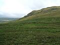
Yarlside Crag on Great Yarlside

