
Waterview Connection facts for kids

While generally considered a "tunnel project", the Waterview Connection also included other large motorway works. The connection consists of the purple (above ground) and dark blue (bored tunnels) sections. The section of SH16 with extra lanes added is shown in light blue.
|
|
| Location | Auckland, New Zealand |
|---|---|
| Proposer | NZ Transport Agency |
| Website | http://www.nzta.govt.nz/projects/waterviewconnection |
| Status | Opened 2 July 2017 |
| Type | Road & tunnel |
| Cost estimate | $1.7 billion |
| Stakeholders | Government of New Zealand, NZ Transport Agency, Auckland Council, Campaign for Better Transport, Cycle Action Auckland, Friends of Oakley Creek, North West Community Association, various further community groups and submitters |
The Waterview Connection is a major motorway section in west/central Auckland, New Zealand. It links State Highway 20 in the south (near Mt Roskill) to State Highway 16 in the west (at Point Chevalier). This connection is a key part of Auckland's Western Ring Route.
The Waterview Connection is about 4.5 kilometers (2.8 miles) long. A big part of it, 2.5 kilometers (1.6 miles), goes through two long tunnels. These Waterview Tunnels are now New Zealand's longest road tunnels, taking over from the Lyttelton Road Tunnel. Experts expect about 83,000 vehicles to use this link every day by 2026. Each tunnel has three lanes for traffic.
Contents
How the Waterview Connection Was Planned
The idea for this project started a long time ago. People began talking about it in 2000, but the general idea for a road in this area goes back even further.
Choosing the Best Route
Many different paths were looked at for the motorway. Some ideas connected to SH16 near the Rosebank Peninsula, while others connected at the Great North Road area in Waterview. It was clear that parts of the road would need to be built underground, especially where it went through Avondale Heights. Some early ideas were rejected because of technical or environmental problems.

The government agency, Transit New Zealand, chose the Waterview connection as its top choice. The local councils in Auckland and Waitakere supported this. However, the first plan for the Waterview route, which changed how cars would get on and off the motorway, was not popular with local people.
Deciding on Bored Tunnels
In 2008, it was announced that digging deep tunnels would be the preferred way to build the road. The NZ Transport Agency (NZTA) first thought about two-lane tunnels, but their studies showed these would get too busy within 10 years. So, they started looking into three-lane tunnels, even though they would cost more.
NZTA wanted to make sure the tunnels were safe and that air quality would not be a problem. They asked for reports on how to manage fumes from the tunnel, comparing their plans to the best methods used around the world.
Looking into Private Funding
The government also explored if a private company could help pay for and build the Waterview Connection. This is called a Public-Private Partnership (PPP). If a PPP was used, drivers might have to pay a small toll (around $2) to use the road. After looking into it, the government decided to stick with public funding for the project.
Worries About Air Quality
Some local groups, especially representatives from Waterview Primary School, were worried about air quality. They thought the reports on tunnel emissions didn't fully consider how tolling might push more traffic onto local roads. They also wanted better air filtering systems and worried about ventilation fans being turned off at quiet times.
A developer building new homes near one of the planned ventilation stacks also raised concerns. He wanted the stack moved further away from the houses.
Questions About Tunnel Costs
In 2009, some people questioned the high cost of building the tunnels. They suggested building the motorway above ground instead, which would be cheaper. They argued that the money saved could be used for other important projects.
The Transport Minister, Steven Joyce, was also concerned about the high cost of the three-lane tunnels. He asked officials to review all options, including building parts of the road above ground, to find a more affordable solution.
A Mix of Tunnels and Surface Road
In May 2009, NZTA announced a new plan. The Waterview Connection would be a mix of surface road, deep bored tunnels, and "cut and cover" tunnels (where a trench is dug, covered, and then built over). This new plan would still allow for three lanes in each direction.

This combined approach was much cheaper than building only deep bored tunnels. It also meant some parts of the road would be above ground, which was a big change from the earlier plans.
Final Plan Confirmed
By the end of 2009, NZTA confirmed the final plan. The tunnels would be built as continuous tunnels, without an open gap in the middle. This was seen as the most cost-effective way to build this section. The new route meant that 205 houses would need to be removed, and underground land would be bought from 105 properties. Construction was set to begin in 2011, with the road opening around 2015 or 2016.
"Road of National Significance" and Fast-Tracking
In 2009, the project was named a "Roads of National Significance". This special status allowed the project to go through a faster approval process. Instead of the usual long process, a special "Board of Enquiry" would make decisions, and their choices could only be challenged on legal points. This was done to avoid long delays that had affected other projects.
The fast-tracked project also included widening State Highway 16 in other areas, which was added to the Waterview Connection's application.
Getting Approvals
The Approval Process
The process for getting permission to build the motorway happened at the same time as choosing the construction company. This was done to save time. A special Board of Inquiry, led by a judge, was set up to review the plans.
During the hearings, several issues became important. People worried about the height and look of the two planned ventilation towers (which would be 25-27 meters tall) and how they might affect air quality. There were also concerns about the impact on local neighborhoods, even those where houses wouldn't be removed.
Board of Inquiry's Decision
In May 2011, the Board of Inquiry made its decisions. They told NZTA to make several important changes:
- Move the northern tunnel exhaust tower further away from Waterview Primary School.
- Move the southern tunnel exhaust tower in Owairaka further away from a park.
- Build both towers to a specific height of "15 meters above ground – not more – not less."
- Pay $8 million to build a new walking and cycling path between Owairaka and Waterview. This was to make up for the loss of green spaces.
Many community groups felt that the Board of Inquiry had listened to their concerns. They believed the changes made the project more acceptable for the local communities.
Building the Waterview Connection
Starting the Work
In March 2010, early work began at the southeastern end of the route. This involved moving a sewer line and a small stream to prepare for the new Maioro Street interchange.
In November 2010, NZTA worked to buy the Faulkner Collins factory and offices to make space for the Maioro Street interchange.
Choosing the Construction Team
In November 2010, NZTA announced the two main groups of companies that would compete to build the project. In mid-2011, the 'Well Connected' group, led by Fletcher Construction, won the contract for $1.3 billion. This group included several other companies, all working together to share the financial risks and rewards.
Early Construction Steps
In January 2012, more early construction work began. This included:
- Setting up construction zones and fences.
- Removing properties needed for the road.
- Building temporary soccer fields and a car park.
- Creating temporary paths for construction vehicles.
- Moving parts of Oakley Creek.
- Moving utility services like power lines.
- Building a temporary new path for Richardson Road.
Local electricity company Vector also worked to supply power to the tunnel sites for construction.
Tunnel Digging Begins
The main tunnel digging began in July 2013. Giant tunnel boring machines (TBMs) were used to dig the two long tunnels.
Opening Day
After some delays due to issues with fire sprinklers, the Waterview Tunnels finally opened. On July 2, 2017, at 12:47 AM, the tunnels officially opened to traffic. Three police cars led the very first vehicles through the northbound tunnel.
Other Projects and Benefits

Besides the motorway itself, other projects were built to help the environment or provide other ways for people to travel.
Railway Line Improvements
The construction of SH20 also included work to prepare for the Avondale–Southdown Line railway. This railway route is very important for moving goods and people across Auckland in the future.
Green Spaces and Parks
Some existing parks and green spaces were used for the motorway construction. To make up for this, NZTA planned to create new green spaces and sports fields near the motorway ramps and above the tunnel entrances.
Paths for Walking and Cycling
A big win for the community was the decision to build a new walking and cycling path along the tunnel route. This path connects the existing SH16 Cycleway with the end of the SH20 Cycleway.
This 2.5-kilometer (1.6-mile) long "Waterview Shared Path" was designed by Auckland Transport. It includes a new bridge over Oakley Creek and another new bridge over the railway line. Construction of the path happened from March 2016 to mid-2017.
Road Widening in Other Areas
As part of the wider project, Maioro Street was widened from two to four lanes. Other nearby roads, like New Windsor Road, Tiverton Road, and Wolverton Road, were also widened to improve traffic flow in the area.
Images for kids
-
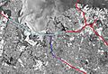
While generally considered a "tunnel project", the Waterview Connection also included other large motorway works. The connection consists of the purple (above ground) and dark blue (bored tunnels) sections. The section of SH16 with extra lanes added is shown in light blue.
-
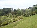
Oakley Creek, near where the bored tunnels in the final (2010) alignments stop (and will be joined to cut and cover built tunnels for the last section towards SH16).
-
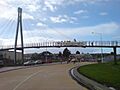
Local protests, such as here at the end of the existing stub of SH20, played a role in a combined surface and tunnel being reconsidered.
-
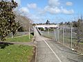
Great North Road and the overbridge of the Northwestern Cycleway. The tunnel will surface just to the west (right hand of the picture).
