Watts Mills, South Carolina facts for kids
Quick facts for kids
Wattsville, South Carolina
Wattsville
|
|
|---|---|

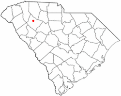
Location in South Carolina
|
|
| Country | United States |
| State | South Carolina |
| County | Laurens |
| Area | |
| • Total | 2.29 sq mi (5.92 km2) |
| • Land | 2.29 sq mi (5.92 km2) |
| • Water | 0.00 sq mi (0.00 km2) |
| Elevation | 650 ft (200 m) |
| Population
(2020)
|
|
| • Total | 1,654 |
| • Density | 722.90/sq mi (279.17/km2) |
| Time zone | UTC-5 (Eastern (EST)) |
| • Summer (DST) | UTC-4 (EDT) |
| ZIP code |
29360
|
| Area code(s) | 864 |
| FIPS code | 45-75220 |
| GNIS feature ID | 2402988 |
Wattsville is a small community in Laurens County, South Carolina, United States. It's not an official city or town, but a "census-designated place" (CDP). This means it's an area that the government counts for statistics. The name Wattsville comes from Watts Mill, which was a textile factory right in the middle of the community. In 2010, about 1,635 people lived here. Wattsville is part of a larger area that includes the cities of Greenville, Mauldin, and Easley.
Contents
Where is Wattsville Located?
Wattsville is found in the central part of Laurens County. It's very close to the city of Laurens, which is the main town of the county.
Major Roads Near Wattsville
Several important roads pass through or near Wattsville:
- U.S. Route 221: This road goes right through Wattsville. If you go north, it leads to Spartanburg, which is about 34 miles away. If you head south through Laurens, it takes you to Greenwood, about 27 miles away.
- South Carolina Highway 49: This highway starts in Wattsville from US 221. It goes northeast to Union, which is about 29 miles from Wattsville.
- Interstate 385: This big highway is about 2 miles north of Wattsville. You can get onto it from both US-221 and SC-49.
Land and Water Around Wattsville
Wattsville covers an area of about 5.9 square kilometers (or 2.29 square miles), and all of it is land. There are no large lakes or rivers directly in the community. The center of Wattsville sits on a raised area of land, and small streams flow from it towards the Little River. The Little River then flows into the Saluda River.
Who Lives in Wattsville?
| Historical population | |||
|---|---|---|---|
| Census | Pop. | %± | |
| 2020 | 1,654 | — | |
| U.S. Decennial Census | |||
In 2010, there were 1,635 people living in Wattsville. These people lived in 564 homes, and 356 of these were families.
Population Details
- Homes: There were 629 housing units in Wattsville.
- Diversity: The community is made up of people from many different backgrounds. In 2010, about 68% of residents were White, and about 16% were African American. There were also people who identified as Native American, Pacific Islander, and from other racial backgrounds. About 16% of the population was Hispanic or Latino.
- Families: About 32.7% of homes had children under 18 living there. Many homes were married couples, while others were single-parent families or individuals living alone.
- Age Groups: The population included people of all ages. About 26% were under 18, and about 10% were 65 years old or older. The average age in Wattsville was 31 years old.
See also
 In Spanish: Watts Mills para niños

