Waugoshance Island facts for kids
 |
|
| Geography | |
|---|---|
| Coordinates | 45°45′50″N 85°04′04″W / 45.7638973°N 85.0678431°W |
| Adjacent bodies of water | Lake Michigan |
| Highest elevation | 587 ft (178.9 m) |
| Administration | |
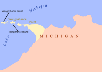
Waugoshance Island is a small island located in Lake Michigan, near Waugoshance Point. It is part of Emmet County in Michigan, specifically within Bliss Township. This island, along with nearby Temperance Island, is a protected area. Both islands are part of the Wilderness State Park, which means they are important for nature and wildlife.
Island Location and Features
Waugoshance Island sits in the waters of Lake Michigan. It is not far from the mainland. The island is known for its shallow waters and sandbars around it. These shallow areas can make it tricky for boats to navigate safely.
Lighthouses Near Waugoshance Island
Several important lighthouses are located in the waters around Waugoshance Island. These lights help guide ships and keep them safe from dangerous shallow areas.
- The Waugoshance Light is located northwest of the island. It stands in shallow water areas called shoals. These shoals are difficult for boats to pass through without guidance.
- The White Shoal Light is another important lighthouse nearby.
- The Grays Reef Light also helps guide ships in this part of Lake Michigan.
These lighthouses have been crucial for safe travel on the lake for many years.
Climate on Waugoshance Island
The climate on Waugoshance Island is typical for the Great Lakes region. Summers are generally warm and pleasant. Winters are cold, with temperatures often dropping below freezing. The island receives a good amount of rain throughout the year. This weather helps support the plants and animals that live there.
 | Kyle Baker |
 | Joseph Yoakum |
 | Laura Wheeler Waring |
 | Henry Ossawa Tanner |


