Waugoshance Point facts for kids
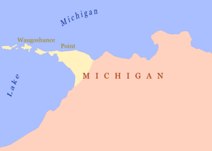
Waugoshance Point is a long piece of land, like a finger, that sticks out into Lake Michigan. It's about 2.5 miles (4 kilometers) long and is located in Emmet County, Michigan. This special place separates the Straits of Mackinac to its north from Sturgeon Bay to the south. It's also part of a bigger area called Wilderness State Park. The closest town is Mackinaw City. The name Waugoshance is interesting! It comes from two languages: the Anishinaabemowin word wah'goosh which means "fox," and the French word anse which means "cove." So, it's like "fox cove."
Contents
Nature and Wildlife at Waugoshance Point
The land along Waugoshance Point rises about 13 feet (4 meters) above the lake. This makes it about 590 feet (180 meters) above sea level. Beyond the very tip of the point, you'll find two islands: Temperance Island and Waugoshance Island.
Habitats and Animals
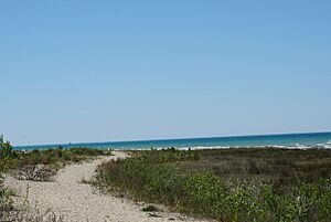
Both the point and the islands have sandy beaches and areas with rocks and gravel. These spots are perfect homes for many birds, especially gulls and wading shore birds. One important bird that lives here is the endangered piping plover.
The area also has many different trees. You can see balsam fir, white spruce, white cedar, white pine, paper birch, and trembling aspen. The wetlands are full of mosses and lichens. If you look in the water offshore, you might find lots of perch and smallmouth bass.
Dangerous Reefs and Lighthouses
Waugoshance Point and its nearby islands are actually parts of a very large underwater reef. This reef stretches out more than 6.5 miles (10.5 kilometers) to the west-northwest. The water above the outer end of the reef is very shallow, only about 9 to 12 feet (2.7 to 3.7 meters deep).
These reefs are extremely dangerous for boats, especially sailing ships and small crafts. They are hidden just below the water's surface. To keep sailors safe, three lighthouses stand nearby. They warn boats away from the hidden dangers and mark the western entrance to the Straits of Mackinac:
- White Shoal Light (45°50′32″N 85°08′07″W / 45.84222°N 85.13528°W)
- Grays Reef Light (45°46′00″N 85°09′12″W / 45.76667°N 85.15333°W)
- Waugoshance Light (45°47′10.2″N 85°05′28.2″W / 45.786167°N 85.091167°W)
A Look at Waugoshance Point's History
Waugoshance Point has a rich history, with many different groups of people living in and exploring the area over hundreds of years.
Early Explorers and Native Americans
In the late summer of 1634, Jean Nicolet was likely the first European explorer to travel through the Mackinac Straits area. At that time, the main people living here were the Odawa and Ojibwe tribes. They called the region Michilimackinac. These tribes, along with the Potawatomi, were part of a strong alliance called the Council of Three Fires. This alliance was formed around the end of the eighth century right there in Michilimackinac.
French and British Influence
French fur traders, known as voyageurs and coureurs des bois, began exploring and settling in this part of Michigan in the late 1600s. In 1671, Father Jacques Marquette started a Christian mission in Saint Ignace. The Native American people in the area generally welcomed these new arrivals, and there were not many conflicts.
Later, after France gave the area to Great Britain, Alexander Henry the elder, a fur trader, was the first Englishman to arrive in 1761. He found that the Native Americans were very upset about being under British rule. They were not friendly toward him or other non-French people.
Henry was present on June 2, 1763, when the Ojibwe and Sauk tribes attacked and took over Fort Michilimackinac. This was part of a larger conflict known as Pontiac's War. Most of the British people at the fort were killed. Alexander Henry was one of the few whose lives were saved. The very first time Waugoshance Point was written about was in Henry's journal, where he described the attack and what happened to him afterward.
Logging and Military Use
During the second half of the 1800s, much of the old, large forests around Waugoshance Point were heavily cut down. The white and red pine trees were in high demand across the country. They were used to build homes, entire cities, furniture, and even railroad ties.
Later, during World War II, Waugoshance Point, its islands, and the old lighthouse were used for military training. It was called the Waugoshance Point Target. Planes from the Naval Air Station in Traverse City (now Cherry Capital Airport) used the area for practice bombing and shooting. They also experimented with radio-controlled (drone) aircraft here. You can still find signs of this military use today, like shell fragments or parts of motors. You can even see the body of a target plane from the parking lot at the point.
Since 1951, Waugoshance Point has been a protected nature wilderness reserve and a place for scientific study.
 | Audre Lorde |
 | John Berry Meachum |
 | Ferdinand Lee Barnett |


