
Wells, British Columbia facts for kids
Quick facts for kids
Wells
|
|
|---|---|
|
District municipality
|
|
| District of Wells | |

Wells
Location in British Columbia
|
|
| Country | Canada |
| Province | British Columbia |
| Region | Cariboo |
| Regional district | Cariboo Regional District |
| Incorporated | 1998 |
| Area | |
| • Total | 158.28 km2 (61.11 sq mi) |
| Elevation | 1,200 m (3,900 ft) |
| Population
(2016)
|
|
| • Total | 217 |
| • Density | 1.5/km2 (4/sq mi) |
| Time zone | UTC-8 (PST) |
| Highways | 26 |
Wells is a small town in British Columbia, Canada. It's found in the Cariboo District. The town is located on BC Highway 26. It is about 74 kilometers (46 miles) from Quesnel. Wells is also just 8 kilometers (5 miles) before the end of the highway at Barkerville.
Wells gets a lot of its money and jobs from tourists. These visitors often pass through on their way to the Bowron Lake Provincial Park. They also visit the historic museum town of Barkerville.
Contents
Wells: A Town of Gold and Growth
Wells started as a "company town." This means a single company, Cariboo Gold Quartz Mine, owned and managed most of it. Fred M. Wells, who the town is named after, searched for minerals here for ten years. He finally found the gold that helped build the company.
How Wells Grew and Shrank
In the 1930s, Wells was very busy. It had about 4,500 people living there. By 1942, it was even bigger than Quesnel or Prince George. But in 1967, the gold and other mines closed down. This caused most people to move away. Today, about 250 people live in Wells. This number doubles during the summer months.
Fun Things to Do in Wells
Between May and September, over 100,000 tourists visit Wells. Many are on their way to Barkerville. Some visitors choose to stay or camp overnight in Wells. The town has many fun things to do, especially in arts and outdoor entertainment. In winter, people come for cross-country skiing and snowmobiling. They also enjoy art and study retreats.
Wells: Understanding the Climate
Wells does not have its own weather station. However, Barkerville does, and it is only about 7 kilometers (4 miles) away. Wells has a type of weather called a subarctic climate. This means it has long, cold, and snowy winters. The summers are short and cool. This weather is because Wells is high up and far north.
Growing Season and Location
The growing season in Wells is short, lasting only about 66 days. This is the time when plants can grow. Wells is located where Jack of Clubs Creek flows. It is also considered the start of the Willow River. This river begins at the outflow of the Jack of Clubs Lake.
| Climate data for Barkerville | |||||||||||||
|---|---|---|---|---|---|---|---|---|---|---|---|---|---|
| Month | Jan | Feb | Mar | Apr | May | Jun | Jul | Aug | Sep | Oct | Nov | Dec | Year |
| Record high °C (°F) | 10.0 (50.0) |
15.0 (59.0) |
17.2 (63.0) |
27.8 (82.0) |
31.5 (88.7) |
33.0 (91.4) |
35.6 (96.1) |
33.9 (93.0) |
32.5 (90.5) |
26.7 (80.1) |
18.9 (66.0) |
14.4 (57.9) |
35.6 (96.1) |
| Mean daily maximum °C (°F) | −2.9 (26.8) |
−0.5 (31.1) |
3.0 (37.4) |
7.2 (45.0) |
12.5 (54.5) |
16.2 (61.2) |
18.8 (65.8) |
19.0 (66.2) |
14.0 (57.2) |
7.2 (45.0) |
−0.3 (31.5) |
−3.5 (25.7) |
7.6 (45.7) |
| Daily mean °C (°F) | −7.5 (18.5) |
−5.9 (21.4) |
−2.8 (27.0) |
1.4 (34.5) |
6.2 (43.2) |
10.0 (50.0) |
12.3 (54.1) |
12.1 (53.8) |
8.0 (46.4) |
2.4 (36.3) |
−4.3 (24.3) |
−7.8 (18.0) |
2.0 (35.6) |
| Mean daily minimum °C (°F) | −12.1 (10.2) |
−11.2 (11.8) |
−8.5 (16.7) |
−4.4 (24.1) |
0.0 (32.0) |
3.8 (38.8) |
5.8 (42.4) |
5.3 (41.5) |
2.1 (35.8) |
−2.3 (27.9) |
−8.3 (17.1) |
−12.0 (10.4) |
−3.5 (25.7) |
| Record low °C (°F) | −46.7 (−52.1) |
−43.3 (−45.9) |
−37.2 (−35.0) |
−26.1 (−15.0) |
−15.0 (5.0) |
−6.7 (19.9) |
−3.9 (25.0) |
−7.8 (18.0) |
−13.3 (8.1) |
−30.5 (−22.9) |
−42.0 (−43.6) |
−41.7 (−43.1) |
−46.7 (−52.1) |
| Average precipitation mm (inches) | 96.0 (3.78) |
60.7 (2.39) |
66.4 (2.61) |
58.2 (2.29) |
77.7 (3.06) |
101.9 (4.01) |
100.0 (3.94) |
80.6 (3.17) |
81.7 (3.22) |
92.3 (3.63) |
111.2 (4.38) |
95.0 (3.74) |
1,021.7 (40.22) |
| Average rainfall mm (inches) | 8.2 (0.32) |
3.4 (0.13) |
8.6 (0.34) |
25.6 (1.01) |
66.0 (2.60) |
101.1 (3.98) |
100.0 (3.94) |
80.6 (3.17) |
80.4 (3.17) |
64.6 (2.54) |
19.3 (0.76) |
2.5 (0.10) |
560.3 (22.06) |
| Average snowfall cm (inches) | 87.8 (34.6) |
57.3 (22.6) |
57.8 (22.8) |
32.6 (12.8) |
11.7 (4.6) |
0.8 (0.3) |
0 (0) |
0 (0) |
1.3 (0.5) |
27.7 (10.9) |
91.9 (36.2) |
92.6 (36.5) |
461.4 (181.7) |
| Average precipitation days (≥ 0.2 mm) | 16.6 | 12.5 | 13.8 | 14.3 | 18.7 | 20.6 | 19.2 | 16.0 | 16.3 | 18.0 | 18.7 | 17.1 | 201.7 |
| Average rainy days (≥ 0.2 mm) | 1.4 | 1.2 | 2.9 | 8.2 | 17.6 | 20.5 | 19.2 | 16.0 | 16.2 | 13.9 | 3.8 | 1.0 | 121.9 |
| Average snowy days (≥ 0.2 cm) | 15.9 | 11.8 | 12.2 | 8.4 | 3.0 | 0.3 | 0 | 0 | 0.6 | 6.5 | 16.4 | 16.6 | 91.8 |
Wells: How Many People Live Here?
In the 2021 Census, Statistics Canada counted the people in Wells. There were 218 people living in 113 homes. This was a small increase from 217 people in 2016. Wells covers an area of about 158 square kilometers (61 square miles). This means there are about 1.4 people living in each square kilometer.
Images for kids
-
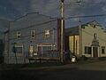
Commercial buildings on Main Street, Sunset Theatre at right

