
West End (Pittsburgh) facts for kids
Quick facts for kids
West End
West End Valley
(formerly Temperanceville) |
|
|---|---|
|
Neighborhood of Pittsburgh
|
|

The Old Stone Inn located at 434 Greentree Road, possibly circa 1756, may be one of the oldest buildings in the region.
|
|
 |
|
| Country | United States |
| State | Pennsylvania |
| County | Allegheny County |
| City | Pittsburgh |
| Area | |
| • Total | 0.2 sq mi (0.5 km2) |
| Population
(2010)
|
|
| • Total | 254 |
| • Density | 1,300/sq mi (490/km2) |
| ZIP Code |
15220
|
| Historical population | ||
|---|---|---|
| Year | Pop. | ±% |
| 1940 | 1,984 | — |
| 1950 | 1,820 | −8.3% |
| 1960 | 1,702 | −6.5% |
| 1970 | 920 | −45.9% |
| 1980 | 604 | −34.3% |
| 1990 | 441 | −27.0% |
| 2000 | 466 | +5.7% |
| 2010 | 254 | −45.5% |
| Source: University of Pittsburgh | ||
West End Village is a cool neighborhood in Pittsburgh, Pennsylvania. It was first called Temperanceville. You can find it in the western part of the city.
The neighborhood has its own special zip code, 15220. It's also part of Pittsburgh's District 2. This district has a special representative on the City Council.
West End Village sits in a small valley. It's south of the Ohio River and very close to downtown Pittsburgh. Temperanceville was started as a "dry town." This means that selling alcohol was not allowed there.
In 1874, Temperanceville became part of Pittsburgh. This is called being "annexed." To help local shops and businesses, the Urban Redevelopment Authority made West End Village a "Mainstreet Pittsburgh district" in 2009.
The West End Bridge crosses the Ohio River. It connects the neighborhood to the North Side of the city. Carson Street links West End Village to Station Square and the South Side. It also connects to the town of McKees Rocks to the west.
Contents
What is the West End Region?
The name "West End" can mean more than just West End Village. It also refers to the larger area around it. This includes West End Village and other neighborhoods like:
- Sheraden
- Elliott
- Windgap
- Esplen
- Ridgemont
- Westwood
- Oakwood
- East Carnegie
- Chartiers City
- Fairywood
- Crafton Heights
- Banksville
Most of the West End region is made up of homes. There are some industries, but not many shopping areas. One famous spot is the West End Overlook. This small park is on a hilltop in the Elliott neighborhood. It gives an amazing view of Downtown Pittsburgh, also known as the Golden Triangle.
People sometimes get confused about the "West End" name. When Pittsburgh took over Temperanceville in 1874, they renamed it West End. Temperanceville was its own town from 1860. It was located in the valley where Saw Mill Run flows into the Ohio River.
The communities southwest of the Ohio River are mostly places where people live. They have local shops and easy access to the rest of the city. Over the past 30 years, the West End neighborhood has changed. Many older homes were removed. This made it harder for people with lower incomes to find places to rent. The goal was to bring in new businesses.
Historic Buildings in West End
The West End has three buildings that are special historic landmarks:
- The German Church, which is now called Jerusalem Baptist Church.
- The Carnegie Branch Library, built in 1899. Andrew Carnegie himself helped get this library built. It was the second Carnegie Library in Pittsburgh. It was also the first place to have a "Library Story Hour" for kids!
- The Old Stone Tavern. This building might be even older than the Fort Pitt Blockhouse. It could be one of the oldest buildings west of the Allegheny Mountains.
The West End Overlook used to be a very popular place to visit. But after improvements in 2004, it became harder to drive up to the top. This made fewer people visit, especially in different seasons.
The Obey House (built in 1823) is another historic building. It's shared by the Elliott and Crafton Heights neighborhoods. It was a "road house" on the Steubenville Pike. This was an important land route going west from Pittsburgh.
Highways and Roads
The West End has important roads that help people get around.
West End Bypass and Banksville Circle
The West End Bypass is a 1.1-mile highway. It's also known as Saw Mill Run Boulevard (U.S. 19, PA 51). It runs from the Penn Lincoln Parkway (Exit 69C) to the West End Circle.
This bypass opened in 1951. It connected to the South Hills through the Banksville Circle. The Banksville Circle was an older road that led to the Parkway and Fort Pitt Tunnels. It gave direct access to the West End through Woodville Avenue. The Banksville Circle was removed in the late 1950s when the Penn Lincoln Parkway was built. However, the Woodville Avenue connection is still there. You can reach it from Parkway Exit 69C or the Carnegie/Airport exit from the West End Bypass.
West End Circle
The West End Circle is a roundabout south of the West End Bridge. Several roads meet here:
- The West End Bypass
- South Main Street (PA Route 60)
- Steuben Street
- West Carson Street (PA 51/PA 837)
The Norfolk Southern railway crosses right through the circle. This used to be the Pennsylvania Railroad. Another railroad, the Wheeling & Lake Erie Railroad, used to cross Steuben Street on a bridge.
In October 2007, a big project started to redesign the West End Circle. New bridges and better connections were built. A new underpass was dug under the Norfolk Southern Railroad. This allows cars to go straight to the West End Bridge (northbound) and the West End Bypass (southbound). The Wheeling and Lake Erie Railroad tracks on Steuben Street were removed. The whole project was finished in October 2010.
Gallery
-
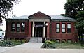
West End Branch of the Carnegie Library of Pittsburgh, built around 1890.
-
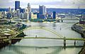
The West End Bridge, built from 1930 to 1932. It connects the West End to the Chateau neighborhood on the North Side.


