West Leederville, Western Australia facts for kids
Quick facts for kids West LeedervillePerth, Western Australia |
|||||||||||||||
|---|---|---|---|---|---|---|---|---|---|---|---|---|---|---|---|

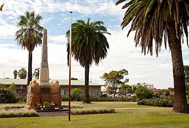
Fallen Soldiers Memorial, West Leederville
|
|||||||||||||||
| Established | 1890s | ||||||||||||||
| Postcode(s) | 6007 | ||||||||||||||
| Area | 1.4 km2 (0.5 sq mi) | ||||||||||||||
| Location | 3 km (2 mi) NW of the Perth CBD | ||||||||||||||
| LGA(s) | Town of Cambridge | ||||||||||||||
| State electorate(s) | Churchlands | ||||||||||||||
| Federal Division(s) | Curtin | ||||||||||||||
|
|||||||||||||||
West Leederville is a cool suburb located about 3 kilometers (2 miles) northwest of Perth, the capital city of Western Australia. It's part of the Town of Cambridge. Before 1972, West Leederville was actually part of Leederville. They became separate when the Mitchell Freeway was built right through the area.
This suburb has a mix of areas. A small part to the east of Southport Street is a business zone with warehouses. This area is handy because it's near the end of the Graham Farmer Freeway. The rest of West Leederville is mostly homes, with many houses close together.
West Leederville is right next to Subiaco Oval and St John of God Subiaco Hospital. Many of the original homes are still standing. They have often been updated and sit next to newer, taller houses. The streets are full of trees, and some homes even have great views of the city! There's also a newer area called "Hill of Tara" with bigger houses and yards. Many of these homes have views of beautiful Lake Monger.
Getting around West Leederville is easy. There's a bus service along Cambridge Street. You can also catch a train at the Leederville train station (on the Joondalup line) or the West Leederville train station (on the Fremantle line).
Contents
Exploring West Leederville's Past
How West Leederville Began
Even though people called it West Leederville for a long time, it officially became a suburb in 1998. It's one of the oldest areas in the Town of Cambridge where people built homes.
West Leederville started when land from William Henry Leeder's estate was sold and divided up in 1891. This led to many houses being built. West Leederville Primary School opened its doors in 1898. Most of the land for homes in West Leederville was divided before 1903.
The Home of the Good Shepherd Convent was built in 1903 by the Good Shepherd Sisters. Today, this building is known as the Catholic Education Centre. By 1925, most of West Leederville was already full of houses.
Old Transport and New Areas
Until the 1950s, a tram used to run down Woolwich Street. This tram line was one of the steepest in the city! It had a very steep slope, about one in fourteen.
In the 1990s, more land was opened up for homes around the Catholic Education Centre on Ruislip Street. This new area was called the Hill of Tara.
Community Hub: Leederville Town Hall
A Place for Everyone
The Leederville Town Hall & Recreation Complex is a very important place in West Leederville. It's located between Holyrood Street, Tower Street, and Cambridge Street. This complex was built because the suburb was growing so fast before World War I.
The famous architect A. E. Clarke designed the Town Hall. A local builder, W. H. Roberts, finished building it in 1916. It has been a central spot for the community for a long time.
Sports and Memories
The Leederville Bowling Club started behind the Town Hall in 1906. It's still a popular place for bowling and social events today. This bowling club was the first sports facility on the site.
The Fallen Soldier’s Memorial is also at the complex. It was designed by Pietro Porcelli and finished in 1924. It helps people remember those who served.
The Leederville Croquet Club also used to be here, from 1908 until 2006. In 2007, the West Leederville Residents Association started a community garden on some unused land next to the bowling club. It's a great place for people to grow plants together!
Famous People from West Leederville
Did you know that a future prime minister of Australia once lived in West Leederville? Bob Hawke, who later became the leader of the country, lived on Tate Street during his childhood.
 | Lonnie Johnson |
 | Granville Woods |
 | Lewis Howard Latimer |
 | James West |

