Subiaco, Western Australia facts for kids
Quick facts for kids SubiacoPerth, Western Australia |
|||||||||||||||
|---|---|---|---|---|---|---|---|---|---|---|---|---|---|---|---|
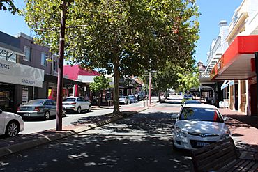
Rokeby Road, Subiaco
|
|||||||||||||||
| Established | 1851 | ||||||||||||||
| Postcode(s) | 6008 | ||||||||||||||
| Area | 3.2 km2 (1.2 sq mi) | ||||||||||||||
| Location | 4 km (2 mi) W of Perth CBD | ||||||||||||||
| LGA(s) |
|
||||||||||||||
| State electorate(s) | Nedlands | ||||||||||||||
| Federal Division(s) | Curtin | ||||||||||||||
|
|||||||||||||||
Subiaco (often called Subi) is a lively suburb located west of Perth, the capital city of Western Australia. It's about 3 kilometers (2 miles) from Perth's city center. Subiaco is known for its mix of shops, businesses, and homes.
In the past, Subiaco was a working-class area with factories and shops. But since the 1990s, it has been rebuilt and improved. Today, it's a popular urban village. It has mostly low-rise buildings and is centered around the Subiaco train station and Rokeby Road.
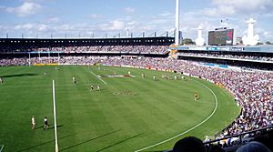
The suburb has three schools: Subiaco Primary School, Perth Modern School, and Bob Hawke College. Important places in Subiaco include Subiaco Oval, which used to be Western Australia's biggest stadium, King Edward Memorial Hospital for Women, and Subiaco railway station.
| Top - 0-9 A B C D E F G H I J K L M N O P Q R S T U V W X Y Z |
Exploring Subiaco's Location
Subiaco is about 3 kilometers (2 miles) west of Perth's main city area. Perth is the largest city in Western Australia. Subiaco is also 6 kilometers (4 miles) east of the Indian Ocean. It's 2 kilometers (1.2 miles) north of the Swan River.
The suburb sits on sandy hills called Spearwood Dunes. These dunes formed about 40,000 years ago. They are part of the larger Swan Coastal Plain.
A Look Back at Subiaco's Past
Early Days and First Settlers
Before Europeans arrived, the Whadjuk Noongar people lived here. They were part of the Mooro group, led by Yellagonga. They lived north of the Swan River.
In 1829, the British started the Swan River Colony (which became Western Australia). In 1846, some Catholic missionaries came to the area. Among them were two Spanish monks, Joseph Benedict Serra and Rosendo Salvado.
In 1849, Serra decided to build a monastery near Perth. He named it the Benedictine Monastery of New Subiaco. This name came from Subiaco, Italy, where the Benedictine monks first started. The monks later moved to New Norcia. The last monks left in 1864. The old monastery buildings were later used as an orphanage. Today, only the Benedictine Stables remain.
The Railway Arrives
In the 1860s, people started buying land in the area. They hoped a railway line would be built. A railway line between Fremantle and Guildford was proposed in 1871. Construction began in 1879. The Fremantle to Guildford railway line opened on March 1, 1881.
The first train station in Subiaco opened in 1883. It was a simple stop for goods and the orphanage. As more people moved in, it became a passenger station.
Growth and Development
In the 1880s and 1890s, gold rushes brought many people to Perth. The government decided to sell land in Subiaco for new homes. The land was laid out in a grid pattern. The first land auction happened in November 1883.
The first house in Subiaco was built in 1886. Many new arrivals, especially from Victoria, bought land. They built simple homes like tents and tin shacks at first. Later, timber houses were built. In 1895, Subiaco had 100 people. By mid-1896, the population grew to 1,300.
In 1896, the first school and a post office opened on Rokeby Road. This road became the main shopping street. The Subiaco Progress Association was formed in 1896. They helped create the Subiaco Road District on April 10, 1896. This was the local government for the area. By the end of 1896, Subiaco had over 2,000 people. This allowed it to become the Municipality of Subiaco on March 26, 1897.
Many churches were built in the late 1890s. Sports clubs like the Subiaco Football Club also formed in 1897. The council set aside land for sports. This land later became Mueller Park and then Subiaco Oval. It became the home of Australian rules football in Western Australia.
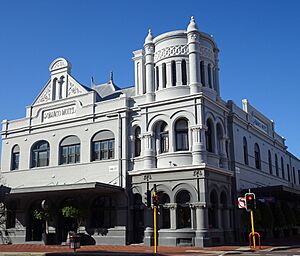
Around 1897, Subiaco railway station moved to the end of Rokeby Road. This made Rokeby Road even more important. The Subiaco Hotel was built around 1898. In 1899, a permanent building for the Subiaco council was built. This area, with the school, post office, and council building, was called Civic Square.
By 1906, the municipality had planted 4,500 street trees. This made Subiaco one of Perth's greenest suburbs.
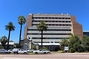
In 1909, a children's hospital opened in Subiaco. It was later named Princess Margaret Hospital for Children. In 1916, the King Edward Memorial Hospital for Women opened.
Perth Modern School opened in 1911. It was the state's first public high school. Students had to pass an exam to get in.
In 1912, the Workers' Homes Board was formed. This was the state's first public housing group. They built homes in Subiaco.
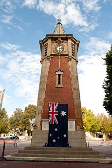
After World War I, Subiaco's growth slowed. In 1922, the council started building a clock tower war memorial. It opened in 1923. The council also focused on making the suburb beautiful again.
In 1924, Daglish railway station opened. It was named after Henry Daglish, a former Mayor of Subiaco. In 1927, the post office moved. The old post office became a library.
In 1936, Subiaco Oval became the main ground for the Western Australian Football League (WAFL). The first WAFL Grand Final was played there that same year.
After World War II
By the late 1940s, Subiaco had grown a lot. In 1952, it officially became the City of Subiaco. A big parade was held to celebrate.
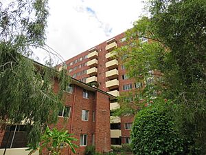
Many older buildings in Subiaco were run down after the war. In the 1950s and 1960s, many old homes were pulled down. New apartment buildings were built, including the 10-story Wandana State Housing Complex. This was Perth's first high-rise public housing building.
Commercial activity also grew. New shops and businesses opened on Hay Street and Rokeby Road. As more people used cars, the tram services stopped in 1958. More car parks were built to help with traffic.
In the 1970s, people started to care more about saving historic buildings. The Subiaco Historical Society was formed in 1973. The council also made rules to protect heritage buildings.
The Perth to Fremantle railway line closed in 1979 but was reopened in 1983.
Modern Redevelopment
Over time, many factories and industrial businesses moved out of Subiaco. This left empty land. The City of Subiaco and the government decided to turn this land into a new "urban village." This project was called "Subi Centro."
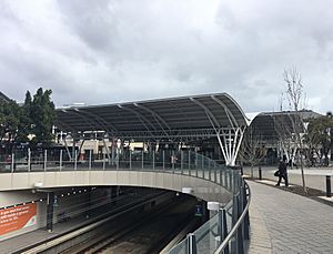
As part of Subi Centro, the Fremantle train line was put into an underground tunnel. A new underground Subiaco station was built. This opened up a lot of land for new homes and shops. A town square called Subiaco Square was built around the station. The station and square opened in December 1998.
In 2020, the government announced the "Subi East" plan. This plan will create a new residential area where Subiaco Oval and Princess Margaret Hospital used to be.
Who Lives in Subiaco?
In 2016, Subiaco had 9,202 people living there. The average age was 38 years old.
Most households in Subiaco are families (57.6%). About 36.1% are single-person households. Many homes are apartments (38.3%), which is much higher than the state average. Most people rent their homes (45.2%).
People in Subiaco often have higher incomes. Many work as professionals or managers. The most common jobs are in hospitals, legal services, and higher education. A high number of residents (49.8%) have a university degree.
The most common backgrounds are English, Australian, Irish, Scottish, and Chinese. Many residents (53.6%) were born in Australia. The most common religions are no religion, Catholic, and Anglican.
Famous Places in Subiaco
Subiaco has many well-known places. These include Subiaco Oval, Mueller Park, the Regal Theatre, and the Subiaco Hotel. You can also see the old Victorian-style houses on Catherine Street and the Subiaco Arts Centre.
Rokeby Road is the main street in Subiaco. It was named after General Henry Montagu, 6th Baron Rokeby. Another important street for shops is Hay Street.
New housing areas like Subi Centro are built on old industrial land. There are also older, historic homes closer to Shenton Park.
Major hospitals in the area are St John of God Subiaco Hospital and King Edward Memorial Hospital for Women.
At the corner of Rokeby and Hamersley Roads, there is a clock tower war memorial. It was built in 1923 to remember soldiers who died in World War I.
Subiaco's Buildings and Style
Subiaco has many beautiful old homes. Many have detailed leadlight windows. A lot of houses in Subiaco are listed as heritage places. This means they are important to the area's history and culture. The City of Subiaco offers walking tours to see some of these homes.
Fun and Culture in Subiaco
Every year, Subiaco hosts a street festival. Rokeby Road is closed for this event. It's called the "Subiaco Street Party." It's a free event with live music, street food, markets, and family fun.
Subiaco is also one of Perth's main nightlife spots. People come from all over to visit its pubs, bars, and nightclubs. The bars and restaurants are mostly around Rokeby Road and Hay Street. Subiaco has small local businesses, as well as bigger chain stores. Some businesses, like the Subiaco Hotel and Farmer Jack Food Market, have been around for over 30 years.
Subiaco is also known for its Subi Farmer's Market. It happens every Saturday morning near the primary school. You can find fresh, organic food and enjoy the lively market atmosphere.
Learning in Subiaco
Subiaco has three schools for students:
- Subiaco Primary School
- Perth Modern School (This is the only public school in the state that selects students based on their academic ability.)
- Bob Hawke College
How Subiaco is Governed
Local Government
Most of Subiaco is part of the City of Subiaco local government area. This city also includes Daglish, Jolimont, and Shenton Park. The suburb of Subiaco covers most of the City's Central and East wards, and part of the North Ward.
A small part of Subiaco, where St John of God Subiaco Hospital is, belongs to the Town of Cambridge. This area does not have any residents.
State Government
For the state government, Subiaco is in the electoral district of Nedlands. This area is represented in the Western Australian Legislative Assembly (the lower house of parliament). The current member for Nedlands is Katrina Stratton from the Australian Labor Party.
Federal Government
For the federal government, Subiaco is in the division of Curtin. This area is represented in the Australian House of Representatives. The current member for Curtin is Celia Hammond from the Liberal Party.
Getting Around Subiaco
Many people in Subiaco use public transport or walk to work. This is more common than in other parts of the state.
Roads
Thomas Street is a big road on Subiaco's south-eastern border. It connects to the Queen Elizabeth II Medical Centre and the University of Western Australia. Railway Road is on the western side.
Hay Street and Roberts Road are one-way streets that go east-west through Subiaco. They lead to Perth's city center. Rokeby Road is a main road that goes north-south through the suburb.
Public Transport
Public transport in Perth is run by Transperth. Subiaco has three train stations on the Fremantle railway line:
- West Leederville railway station: This station is near Subiaco Oval.
- Subiaco railway station: This is the busiest station in Subiaco. It's in the center of Subiaco Square. Many bus routes connect here.
- Daglish railway station: This station is on the border with Daglish.
Many bus services also run through Subiaco. Most go east-west, connecting to Perth's city center or suburbs further west. Others link to different train lines or hospitals.
 | William L. Dawson |
 | W. E. B. Du Bois |
 | Harry Belafonte |


