West Mansfield, Ohio facts for kids
Quick facts for kids
West Mansfield
|
|
|---|---|
|
Village
|
|
| Village of West Mansfield | |

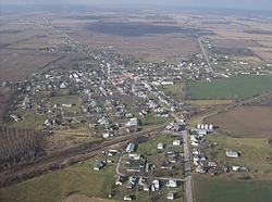
Aerial view of West Mansfield from the east
|
|

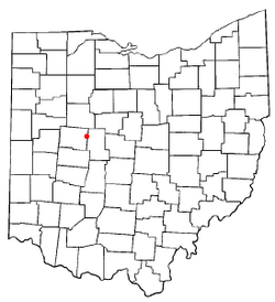
Location of West Mansfield, Ohio
|
|

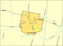
Detailed map of West Mansfield
|
|
| Country | United States |
| State | Ohio |
| Counties | Logan |
| Townships | Bokescreek, Perry |
| Area | |
| • Total | 0.86 sq mi (2.22 km2) |
| • Land | 0.83 sq mi (2.16 km2) |
| • Water | 0.03 sq mi (0.06 km2) |
| Elevation | 1,083 ft (330 m) |
| Population
(2020)
|
|
| • Total | 749 |
| • Density | 900.24/sq mi (347.42/km2) |
| Time zone | UTC-5 (Eastern (EST)) |
| • Summer (DST) | UTC-4 (EDT) |
| ZIP code |
43358
|
| Area code(s) | 937, 326 |
| FIPS code | 39-83818 |
| GNIS feature ID | 2400138 |
West Mansfield is a small village located in Logan County, Ohio, USA. It is also officially known as the Village of West Mansfield. In 2020, about 749 people lived there. The community has its own library branch, which is part of the Logan County District Library.
Contents
History of West Mansfield
West Mansfield was first planned and settled in 1848. A post office opened in the village in 1863. This post office has been serving the community ever since.
Geography and Location
West Mansfield is located in the state of Ohio. The United States Census Bureau reports that the village covers a total area of about 0.86 square miles (2.22 square kilometers). Most of this area, about 0.83 square miles (2.16 square kilometers), is land. A small part, about 0.03 square miles (0.06 square kilometers), is water.
People of West Mansfield
This section shares information about the people living in West Mansfield. This data comes from official counts called censuses.
Population Changes Over Time
The number of people living in West Mansfield has changed over many years. Here is a look at the population from 1880 to 2020:
| Historical population | |||
|---|---|---|---|
| Census | Pop. | %± | |
| 1880 | 333 | — | |
| 1890 | 431 | 29.4% | |
| 1900 | 875 | 103.0% | |
| 1910 | 913 | 4.3% | |
| 1920 | 737 | −19.3% | |
| 1930 | 675 | −8.4% | |
| 1940 | 739 | 9.5% | |
| 1950 | 756 | 2.3% | |
| 1960 | 791 | 4.6% | |
| 1970 | 753 | −4.8% | |
| 1980 | 716 | −4.9% | |
| 1990 | 830 | 15.9% | |
| 2000 | 700 | −15.7% | |
| 2010 | 682 | −2.6% | |
| 2020 | 749 | 9.8% | |
| U.S. Decennial Census | |||
2010 Census Information
In 2010, there were 682 people living in West Mansfield. These people lived in 271 households, and 190 of these were families. The village had about 821.7 people per square mile (317.3 people per square kilometer). There were 309 housing units, which are homes or apartments.
Most people in the village were White (96.6%). A smaller number were African American (0.9%), Native American (0.1%), or Asian (0.1%). About 2.2% of the population were from two or more racial backgrounds. A very small number (0.1%) were Hispanic or Latino.
Many households (38.0%) had children under 18 living with them. About 52.0% of households were married couples living together. Some households had a female head of the house with no husband (12.2%), or a male head of the house with no wife (5.9%). About 29.9% of households were not families.
Almost a quarter of all households (24.7%) were made up of individuals living alone. About 9.3% of these individuals were 65 years old or older. On average, each household had 2.52 people, and each family had 2.99 people.
The average age of people in the village was 36 years old.
- 26.2% of residents were under 18.
- 7.1% were between 18 and 24.
- 27.3% were between 25 and 44.
- 24.8% were between 45 and 64.
- 14.5% were 65 years or older.
The village had an equal number of males and females, with 50.0% male and 50.0% female residents.
Transportation in West Mansfield
State Route 47 is an important road in West Mansfield. This road goes through the village's downtown area, running from east to west.
See also
 In Spanish: West Mansfield (Ohio) para niños
 | James Van Der Zee |
 | Alma Thomas |
 | Ellis Wilson |
 | Margaret Taylor-Burroughs |

