
West Shreve Run facts for kids
Quick facts for kids West Shreve Run |
|
|---|---|


|
|
| Other name(s) | Tributary to Oil Creek |
| Country | United States |
| State | Pennsylvania |
| County | Crawford Erie |
| Township | Bloomfield Union |
| Physical characteristics | |
| Main source | divide between West Shreve Run and South Branch French Creek about 1 mile south of Hinckley Corners, Pennsylvania 1,630 ft (500 m) 41°51′22″N 079°53′09″W / 41.85611°N 79.88583°W |
| River mouth | Lake Canadohta Lake Canadohta 1,389 ft (423 m) 41°49′09″N 079°50′18″W / 41.81917°N 79.83833°W |
| Length | 4.06 mi (6.53 km) |
| Basin features | |
| Progression | south |
| River system | Allegheny River (Oil Creek) |
| Basin size | 3.8 square miles (9.8 km2) |
| Tributaries |
|
| Bridges | Shreve Ridge Road, Old Valley Road (x2), Lincolnville Road |
West Shreve Run is a small stream, about 4.06 mi (6.53 km) long. It flows into Lake Canadohta, which is part of Oil Creek. This stream is located in Crawford County, Pennsylvania. About half of the land around the stream is covered by forests, and 43% is used for farming.
The Stream's Journey
West Shreve Run starts its journey about 1 mile south of Hinckley Corners, Pennsylvania. It begins near a high point that separates its waters from those of the South Branch French Creek.
The stream then flows south. It travels through an area called the Erie Drift Plain. Finally, it reaches Lake Canadohta, which is connected to Oil Creek.
What is a Watershed?
A watershed is an area of land where all the water drains into a single stream, river, or lake. Think of it like a giant bowl that collects all the rain and snow, sending it to one main waterway.
West Shreve Run's Watershed
The watershed for West Shreve Run covers about 3.8 square miles (9.8 km2) of land. This area gets about 46.4 inches of rain and snow each year. About 50% of this watershed is covered by forests.
Images for kids
-
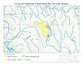
This map shows the path of West Shreve Run and the area of land that drains into it.
.jpg)
