Western Cape facts for kids
Quick facts for kids
Western Cape
Wes-Kaap
iNtshona-Koloni |
|
|---|---|
| Motto(s):
Spes Bona (Good Hope)
|
|

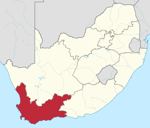
Location of the Western Cape in South Africa
|
|
| Country | South Africa |
| Established | 27 April 1994 |
| Capital | Cape Town |
| Districts |
6
City of Cape Town
West Coast Cape Winelands Overberg Eden Central Karoo |
| Government | |
| • Type | Parliamentary system |
| Area | |
| • Total | 129,462 km2 (49,986 sq mi) |
| Area rank | 4th in South Africa |
| Highest elevation | 2,325 m (7,628 ft) |
| Lowest elevation | 0 m (0 ft) |
| Population
(2011)
|
|
| • Total | 5,822,734 |
| • Estimate
(2018)
|
6,621,100 |
| • Rank | 3rd in South Africa |
| • Density | 44.97639/km2 (116.4883/sq mi) |
| • Density rank | 4th in South Africa |
| Population groups | |
| • Coloured | 48.8% |
| • African | 32.8% |
| • White | 15.7% |
| • Indian or Asian | 1.0% |
| Languages | |
| • Afrikaans | 49.7% |
| • Xhosa | 24.7% |
| • English | 20.2% |
| Time zone | UTC+2 (SAST) |
| ISO 3166 code | ZA-WC |
The Western Cape is one of the nine provinces in South Africa. It is located at the country's southwestern tip. This province was formed in 1994. It was created when the old Cape Colony was divided into three new areas. Most people in the Western Cape live in the big city area of Cape Town. Cape Town is also the capital city of the province.
Contents
Discover the Western Cape
The Western Cape is a special place in South Africa. It is known for its beautiful nature and diverse people. The province has a unique history and culture. It is a popular spot for both locals and tourists.
Where is the Western Cape?
The Western Cape shares its borders with two other provinces. These are the Northern Cape and the Eastern Cape. To its west and south, the province meets the Atlantic Ocean. The famous Cape of Good Hope is found at its southwestern point. This area is where the Atlantic and Indian Oceans are often said to meet.
What is the Western Cape like?
The Western Cape covers a large area of about 129,462 square kilometers. This makes it the fourth largest province in South Africa. It has a varied landscape, from long coastlines to high mountains. The highest point in the province is over 2,300 meters above sea level.
People and Languages
The Western Cape is home to many different people. In 2018, about 6.6 million people lived here. The province is known for its mix of cultures. Many different languages are spoken by its residents.
The main languages spoken are:
- Afrikaans: spoken by almost half of the people.
- Xhosa: spoken by about a quarter of the people.
- English: spoken by about one-fifth of the people.
This mix of languages shows the rich cultural background of the province.
How is the Western Cape Governed?
The Western Cape is governed by a system called a Parliamentary system. This means that people vote for representatives. These representatives then make laws for the province. The leader of the province is called the Premier. The current Premier is Alan Winde. The laws are made by the Western Cape Provincial Parliament. The main political party in charge is the DA.
Districts of the Province
The Western Cape is divided into six main areas called districts. These districts help manage local services. They include:
- City of Cape Town (a large metropolitan area)
- West Coast
- Cape Winelands
- Overberg
- Eden
- Central Karoo
Images for kids
See also
 In Spanish: Provincia del Cabo Occidental para niños
 | Kyle Baker |
 | Joseph Yoakum |
 | Laura Wheeler Waring |
 | Henry Ossawa Tanner |


