Weston Hill facts for kids
Quick facts for kids Weston Hill |
|
|---|---|

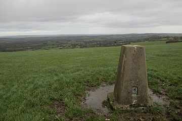
Trig Point
|
|
| Highest point | |
| Elevation | 250 m (820 ft) |
| Geography | |
| Location | Dorset, England |
| Parent range | Dorset Downs |
| OS grid | ST504045 |
| Topo map | OS Explorer |
Weston Hill is a hill in the county of Dorset in southern England. It stands about 250 meters (820 feet) high. You can find it about 1 kilometer (0.6 miles) west of a village called Corscombe. This hill is part of a larger area known as the Dorset Downs. It gets its name from a small nearby place called Weston.
Contents
Exploring Weston Hill
Weston Hill is a noticeable feature in the Dorset countryside. It's a great example of the gentle, rolling hills found in this part of England.
Where is Weston Hill Located?
Weston Hill is found in the beautiful county of Dorset. It's quite easy to spot, as it's right next to the A 356 road. This road connects different towns and villages in the area. The hill is part of the Dorset Downs, which is a range of chalk hills that stretch across the county.
What Can You See at the Top?
At the very top of Weston Hill, you'll find a special marker called a trig point. A trig point is a concrete pillar used by mapmakers to help create accurate maps of the land. It's like a special sign that marks the exact highest spot. Just a short distance away, about 100 meters (330 feet) to the northwest, there's also a tall transmission mast. This mast helps send radio and television signals across the area.
The Landscape Around Weston Hill
If you look to the east from Weston Hill, the ground drops down quite steeply towards the village of Corscombe. This means you get a good view of the valley below. To the southwest, the land slopes gently downwards towards another area called Beaminster Down. After that, it drops sharply again at a place called Mintern's Hill, leading towards the town of Beaminster. The views from the hill show off the varied and pretty landscape of Dorset.

