Westphalia, Indiana facts for kids
Quick facts for kids
Westphalia, Indiana
|
|
|---|---|

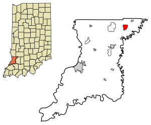
Location in Knox County, Indiana
|
|
| Country | United States |
| State | Indiana |
| County | Knox |
| Township | Vigo |
| Named for | Westphalia |
| Area | |
| • Total | 2.06 sq mi (5.34 km2) |
| • Land | 2.06 sq mi (5.34 km2) |
| • Water | 0.00 sq mi (0.00 km2) |
| Elevation | 466 ft (142 m) |
| Population
(2020)
|
|
| • Total | 181 |
| • Density | 87.78/sq mi (33.89/km2) |
| Time zone | UTC-5 (EST) |
| • Summer (DST) | UTC-4 (EDT) |
| ZIP code |
47596
|
| FIPS code | 18-83204 |
| GNIS feature ID | 445855 |
Westphalia is a small community in Knox County, Indiana, in the United States. It is known as an "unincorporated community" and a "census-designated place" (CDP). This means it's a recognized area for gathering population data, but it doesn't have its own local government like a city or town.
As of the 2010 census, about 202 people lived in Westphalia. It is located within Vigo Township.
Contents
History of Westphalia
Westphalia was officially started, or "laid out," in December 1881. Many of the first people who settled here were Germans. They named the community after a region in Germany called Westphalia.
The Westphalia post office opened in 1881. Over the years, many different businesses have been part of the community. These included a variety store, an antique shop, a hotel, and a blacksmith. There was also an elevator (likely for grain), a photo studio, a mine supply store, and the Westphalia elementary school.
Where is Westphalia Located?
Westphalia is found in the northeastern part of Knox County. You can find its exact spot using coordinates: 38°51′46″N 87°13′32″W.
Indiana State Road 67 goes right through the middle of Westphalia. This road connects Westphalia to other nearby towns. If you go northeast on SR 67 for about 3 miles (5 km), you'll reach Sandborn. If you travel southwest for about 4 miles (6 km), you'll get to Edwardsport. The county seat, Vincennes, is about 23 miles (37 km) southwest.
Another road, Indiana State Road 58, joins SR 67 as it leaves Westphalia to the northeast. However, SR 58 also leads west for about 5 miles (8 km) to Freelandville.
According to the U.S. Census Bureau, the Westphalia census-designated place covers an area of about 2.06 square miles (5.34 square kilometers). All of this area is land.
Population of Westphalia
| Historical population | |||
|---|---|---|---|
| Census | Pop. | %± | |
| 2020 | 181 | — | |
| U.S. Decennial Census | |||
The population of Westphalia has changed over time. In 2010, there were 202 people living there. By the 2020 census, the population was 181. This information helps us understand how many people live in the community.
Things to See and Do in Westphalia
Even though Westphalia is a small, rural community, it has a few interesting places. You can find a playground, which is a great spot for kids to play. There is also a church, the Salem United Church of Christ, which serves the community.
Westphalia also has senior apartments for older residents. And, of course, there's a post office where people can send and receive mail.
See also
 In Spanish: Westphalia (Indiana) para niños
 | May Edward Chinn |
 | Rebecca Cole |
 | Alexa Canady |
 | Dorothy Lavinia Brown |


